August 21, 2016, Mile 2519: Not My Favorite Stretch of Trail

At a campsite, mile 2519

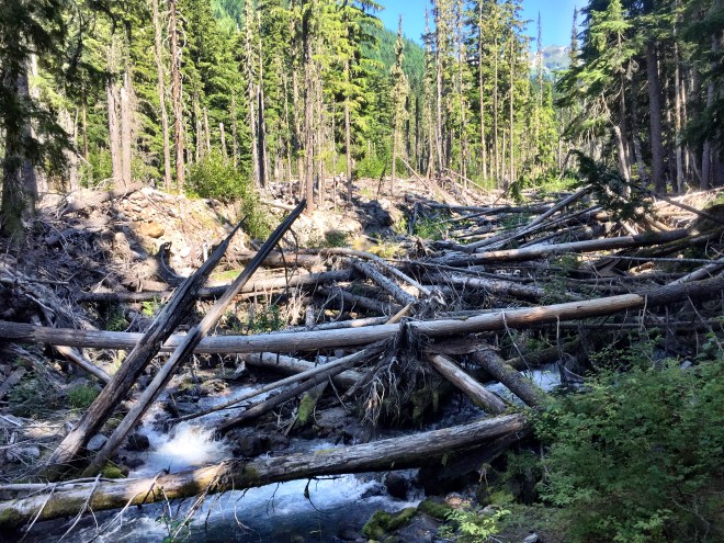
Today I coined a new phrase: Full Body Workout Blowdowns. These are blowdowns (fallen trees) which necessitate much more than a simple slide over the top, or trot around the end. They may involve old growth trees, tangled masses of young-ish alder, or any of the above. They can also require a belly crawl underneath, or a descent down a steep slope followed by a full-on veggie belay to pull yourself up. Crossfit has *nothing* on these bad boys, in my not-so-humble opinion.

The trail is also highly overgrown. Near the tops of ridges, you’ll get berry bushes and other high-alpine plants. And near the river bottoms, you’ll get masses of lowland shrubs and trees. In both of these areas, the overgrowth hasn’t been brushed back in quite some time. And if things haven’t recently been brushed back, the trail can’t be maintained: there was quite a bit of slump on all sides, which couldn’t be seen unless you looked carefully through the overgrowth. The overgrowth also makes ascents difficult. If I’ve got a rhythm going, I normally focus on my feet, and my arms/poles help keep pace. With this kind of overgrowth, I have to punch and push my way through.

What this all meant for me is an eight mile day. A couple of weeks ago I was doing double this, or even more, so I was mighty frustrated.

Please note that I am NOT under any circumstances dissing our beloved trail crews. Last winter was horrific in terms of blowdowns and other problems. I am really impressed with their ability to clear as much as they did, and having hiked this section, I am that much more grateful to them for their efforts. The work they do is fantastic. For more information on the local trail crews, check out the North 350 Blades. They have taken responsibility for the northernmost 350 miles of the PCT, or White Pass to the Canadian Border. “Blades” refers to their crosscut saws. Thank you to their awesome volunteers!

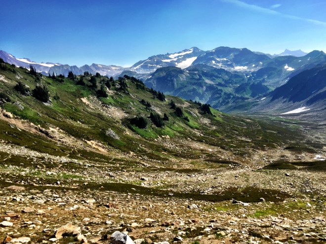
But even the slowest of days has its delights. I hiked down the Fire Creek drainage, with deep blue skies and brilliant greens.

img_2944

img_2942
Fire Creek

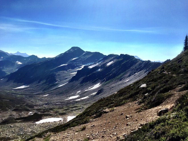
From there, I climbed the ridge to Laslaih Creek Trail 2517. The ridge was wide open, with views everywhere. And the coolest thing for me was seeing an original Cascade Crest Trail sign! The Cascade Crest Trail was the original Washington section of the PCT; it and five other trails were merged into the PCT in 1973 (http://www.pcta.org/about-us/history/).

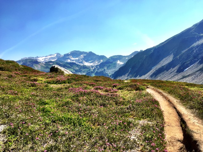
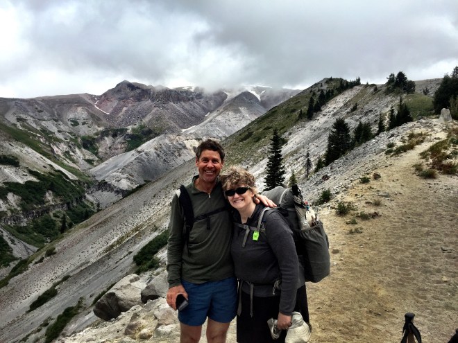
I sat on top of the ridge for awhile, chatting with a thru named Roberto. We admired the views…they are really stunning. The further north you go, the more spectacular they are. Right now, though, they showed gathering clouds. The forecast told of rain, and so I left the vistas and headed downhill toward my campsite.

img_2941img_2946

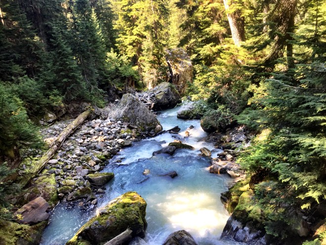
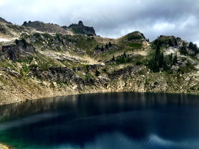
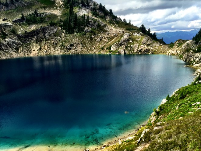
The campsite was partway down into the Milk Creek drainage. The first stop was the gorgeous Mica Lake 2518. The water is a perfect turquoise (which I couldn’t capture, but which blew my mind), and although I wasn’t planning on camping there, I spent a little bit just soaking in the beauty.

img_2955img_2952img_2951

Reluctantly, I headed downhill. I decided a little extra sleep would help my attitude, so I set everything up in preparation for the looming rain, and made dinner in my tent, in hopes to get to bed early.

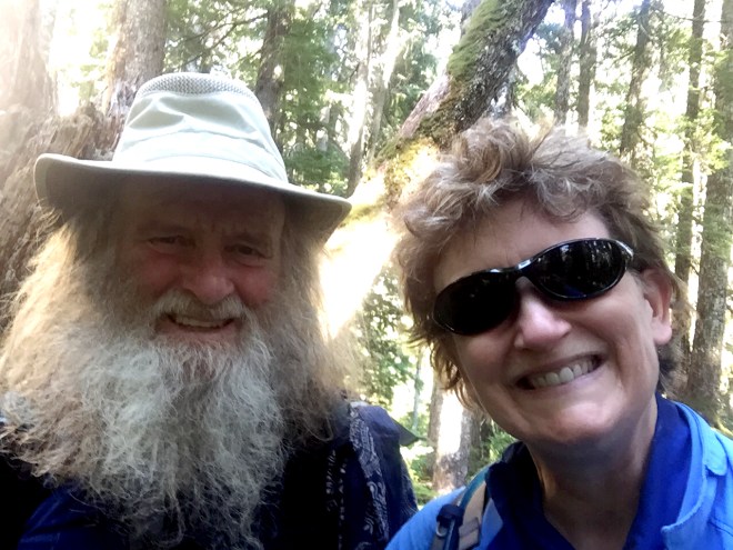
I had one campsite-mate: a guy named Matt, in his early 20s, who is an engineering student from Ohio. He had lots of questions, as this was his first real backpacking trip, so I did my best to answer them. He seemed nice, and it was good to have a fellow traveler in camp.

Bedtime at 7:30!

August 20, 2016, Mile 2512: Billy Goat!

At Glacier Creek, mile 2512

I left my stealth camp fairly early, again to beat the heat. I needed to knock off the elevation gain before the sun was high in the sky.

Mid morning, I finally met the PCT! It was pretty awesome

img_2916img_2924

So why did I enter at the North Fork Sauk River Trail? In 2015, I did Stevens 2461 to Lake Sally Ann 2490, before bailing due to weather and wildfire. In 2014, I did Cady Creek 2485 to Red Pass 2502. And this year, I’m starting at 2500. I’m really glad I did the 2014 section, as the North Fork trail is one of the only runup trails in decent shape.

I stopped at Red Pass, to enjoy the views and have an early lunch. It’s a lovely place, where you can see peaks on both sides of the crest.

img_2925IMG_2920.JPGimg_2926

And then I stepped off into new territory. Cool! The trail winds down into a huge basin, toward the White Chuck River drainage. Lovely streams were everywhere, along a gentle downward slope. The tread was easy; it was a wonderful section to be hiked on my first full day.

img_2927img_2928img_2929

img_2935
Bridge over the White Chuck River
img_2938
White Chuck River. The larger creeks in the section drain the glaciers on Glacier Peak. They are usually pretty silty, and aren’t great for getting water.


img_2933
Baekos Creek. This is what winter storms and spring meltoff can do.

Suddenly I looked up, and there was Billy Goat! He is a legend among PCT hikers. He’s 77 years old, and spends almost all of his time hiking and walking. I gasped, “You’re Billy Goat!” and he smiled at me.

I told him it was a great privilege for me to meet him. He looked at me and asked if I ever felt discouraged. It seemed a bit unusual, but I said that, yes, I get discouraged all of the time.

He told me that he did too, and that his emotions will change ten or more times a day. Then he said to just ignore them, and keep on walking. Either he was reading my mind, or he knew what was ahead on the trail, or both.

Billy Goat has recently undergone heart surgery, and has Type 2 diabetes. But he just keeps going; with every setback, he keeps pushing to walk some more. In fact, he’s got 47,500 trail miles to his credit, and his goal is to hit 50,000 by his eightieth birthday. When I reiterated what a privilege it was to meet him, he looked slightly puzzled and asked why. I responded by saying that he was a reminder to us all to just keep walking.

We took a picture together, and he gave me a big hug, before heading south on the trail.

img_2930

Words of wisdom: less than a tenth of a mile north was the beginning of Trail Hell, a 30+ mile stretch of massive blowdowns, thick overgrowth, and slumping trail; this was over 9000 feet elevation gain and 9000 feet loss. Not the worst trail I’ve ever seen, but it was relentless, and had a certain soul-sucking quality about it. I plowed on, aiming for Glacier Creek, five miles up the trail. Appropriate, I suppose, as my pace could only be described as glacial.

But I finally had the chance to cross a semi-famous bridge, which I’d been looking forward to seeing. In October 2003, Washington experienced a record-breaking storm. Bridges, trails, campgrounds, and roads in this area were damaged, or completely obliterated. A chunk of the PCT simply disappeared. The well-known Kennedy Hot Springs vanished under several feet of debris. Even the Skyline Bridge, with huge I-beams and concrete footings, was destroyed. This article, published shortly after the storm, describes the damage.

Comparatively speaking, the Kennedy Creek bridge survived intact. Nevertheless, it can be a tricky crossing when the spring snowmelt comes crashing down the creek. This day, the water was low.

img_2939img_2940

As I approached Glacier Creek, with darkness rapidly falling, I had to violate one of Liz’s Guiding Principles of Hiking…never hike with my clear lined bifocals, which increases the risk of stumbling by a significant margin. I got to the creek at the tail end of dusk, threw my tent on a flattish spot, and hit the rack.

August 19, 2016, Mile 2500: Canada or Bust

We got home from Cascade Locks on the 12th, and spent a lot of time doing family things. First up was a trip to our favorite Mexican restaurant, and the next couple of days were spent transcribing my notes and adding to my blog. I spent quality time cleaning and reorganizing gear, and mailed my final resupply, to Stehekin. I sent off my old tent body with the failed zipper, and added the new body instead. But for a variety of reasons, it was a very fatiguing week. Such is life, but it was important that I go slowly at first to regain my energy.

On Friday the 19th, we headed out, via a breakfast stop at the Maltby Café. We drove up the Mountain Loop Highway, to the North Fork of the Sauk trail. Goodbyes were said, and I headed uphill midday.

img_2914img_2913

The North Fork of the Sauk trail is 5.5 miles of relative flat, which makes for a great basic backpacking trip. After that, it gains 3000 feet in 2.8 miles, a lot of which are in the first half.

With the aforementioned fatigue, it became clear that I wasn’t going to reach the trail, nor my desired first campsite. So I began the search for a stealth campsite. This is a spot which isn’t really visible to the trail, and which doesn’t violate Leave No Trace too badly, but is a functional spot. I found a spot maybe 50 feet downhill from the trail, with a mostly clear flat patch just wider than my tent. Score!

That new tent body, and the functional zipper, are proving their worth. The biting flies are out in force; I probably have ten of them smeared inside my tent, from their attempted incursion.

It’s supposed to be smoky hot tomorrow, so I’m planning to be up by 5:30. I used the umbrella today, which helped. I’ve got a clip that helps hold it in position. The jury’s still out, though, as to whether it’s a net win.

The elevation change is far different here than it was in Oregon. So my mileage will definitely drop from 15-20. I’ll have to monitor that, and be realistic about the difficulty of the trail. I’ve heard more than one highly experienced hiker caution about lower mileage.

August 12, 2016, Home: Transition

At home

My original plan was that my friend Carol would pick me up in Cascade Locks, the day after I arrived. Steve made arrangements otherwise…he would pick me up at Shrek’s, and we would spend the day in town, followed by a night at the Best Western. It was a wonderful way to transition from trail life back home.

We spent quality time sharing bubbly in the park (shh, don’t tell). And then we had a beer or two at Thunder Mountain. Of course, no trip to Cascade Locks is complete without a giant ice cream. And finally, we spent the evening in the hot tub. I felt totally pampered!

The next day, we headed north. It was a bittersweet trip. Cascade Locks is where I began my PCT journey, two years ago. This week, I connected the dots, in a little town that will always hold a piece of my heart.

After a week at home, I began the second half of my hike, this time in Washington.

2014-08-20 (2)
Bridge of the Gods, taken at the start of my first section hike in 2014

August 10, 2016, Mile 2144: Cascade Locks

At Shrek’s, in Cascade Locks, mile 2144

Only 12 miles today, but it was a long, steep downhill slog, with a net elevation loss of almost 5000 ft. I packed up my slightly drier gear, turned on a podcast, and headed out.

I was still schlepping the extra water, which was good. There were no water sources until near the end of the trail. This is also one of the dings against the main trail (as opposed to the alternate).

I rounded a corner, just before heading down, and suddenly I could hear a train whistle. Civilization kept intruding, little by little. Trains, road noise, airplanes…

The trail became wider, and the tread easier, until I hit the end. Cascade Locks, 2144.

IMG_2683

I made my way in to town, passing a fruit stand (ice cold cherries!).

And then I stopped in at Cascade Ale House, where I found Sisyphus, Notion, Animal Lover, Lock, and Caps! It was old home week. I had a burger and a beer, took pictures, hung out, and all kinds of other stuff. I dropped some things in the hiker box, and just had a grand time. Big hat tip to Jules, the proprietor, who shared this picture of the trail registry!

img_3107

Steve and I ate dinner at the Ale House two years ago. But then I didn’t know anybody. This year, I am part of the hiker community, and the difference is awesome.

IMG_2680

After I finished my dinner, I stopped at the grocery store to grab a bag of munchies, and then headed up to Shrek’s.

Shrek is overseas this year, but in his stead Sugar Mama, Strange Bird, MacGyver and Lilypad are holding down the fort. There were maybe 15 hikers there, with tents pitched all over the yard.

I grabbed a small piece of real estate, set up my tent, and went to take a shower. It was fantastic! Shrek had built a small add-on to his house, which included an entry way with a small bed, plus a bathroom with a shower and washer/dryer. Two girls, Zinger and Last Call, were hanging out while they washed their clothes. I hung out and chatted with them, waiting to wash the stench out of my laundry. Steve will never understand how much this simple gesture means to him.

While the majority of the 20-something hikers went down to the bar, I stayed up at Shrek’s and hung out. MacGyver and Lilypad wanted to know my story, so I sat down and told them a bit about me. I guess I’m a touch out of the ordinary, and that’s okay. MacGyver cooked up some chicken wings as well, which tasted incredible. Something about real food…

Steve will be here in the morning…can’t wait! It’s hard to believe that this half of my hike is over. I have learned so much, and pushed myself beyond what I thought I could do.

August 9, 2016, Mile 2132: Plugging Away

Today was a long plod. I chatted with my campsite-mates this morning, but the big focus was getting my rain-damp gear put away. It was foggy and damp yesterday, and it’s even more so today.

Indian Springs Campground 2125 is the jumpoff point for the Eagle Creek Alternate trail. This trail starts with a brutal descent before mellowing a bit and winding through several lovely waterfalls. The only beta I’ve had on this is that the first two miles are 1600 ft of loss, over nasty rocks. Because it’s been so foggy, I don’t think I’m going to do the alternate…why punish yourself when you can’t see anything anyway?

So once at Indian Springs, I bit the bullet and stayed on the main trail. Sigh.

A bit later, I came to Wahtum Lake 2128. It took awhile to find a spot to tank up (north end of the lake). I knew I might have no water source between here and Cascade Locks 2144, so I had to really fill up.

IMG_2676

Then I took a wrong turn, which cost me maybe half an hour. My GPS is great, though, and it was an easy fix. But my destination for the night was a campsite at 2132, and by the time I’d climbed up the ridge, it was nearly dark.

Apparently, my camp-making fu is strong, because I got everything set up and nobody heard anything, according to reports from the next day.

Tomorrow, Cascade Locks!

August 8, 2016, Mile 2116: Adventures in Water Crossing

At Salvation Spring, Mile 2116

Got up early, and threw my condensation-laden gear into my pack. Next stop: the Sandy River. It was just around the corner, and my first task was to take the lay of the land…er…river.

Where the trail met the river, there were rocks to cross. But everyone I had talked to said to use the ad hoc bridge made of branches. This was maybe 20 feet long, and made of half a dozen branches, ranging in diameter from 1-2 inches. The bridge wasn’t stable, but it was crossable. And it appeared to be preferable to a ford.

Those of you playing along at home will know that I hate unstable bridges. I have just enough vertigo to make my hikes interesting, and when crossing a river, interesting is the watchword of the day. If I could choose anything about my hiking self that I could change, this would be it. It’s frustrating, sometimes downright embarrassing, and is generally a pain in the neck. It’s probably also designed to keep me humble (sigh).

Anyway, I inched across the bridge, and let out a big sigh of relief on the other side. Meh.

IMG_2670

Just up from the river, the PCT has an alternate route, which is a loop near Ramona Falls. It’s a lovely waterfall, light and lacy. This is one of two alternates in northern Oregon, and I’m glad I took the time to see this one.

IMG_2672

Immediately after the Ramona Alternate rejoined the trail, I had to cross the Muddy Fork. This is a large stream, and the bridge came down years ago. In its place are two large logs, and while at the beginning you can use the upper log as a handrail, by halfway across you need to use a (slack) line instead. Fairly straightforward, but it helped to have another hiker take my poles and give me a hand up at the end. In turn, I waited until the next guy came along, and took his poles the same way.

IMG_2675

As it turned out, the guy I helped is from Ballard. He’s working in web design, and was really interested in the program I’m taking. He also thought it was awesome that my grandma had graduated from Ballard, maybe 85 years before he did!

So tonight’s goal was Salvation Spring 2116. When I arrived, there was one tent set up, with a brother/sister pair about my age, Notion and Sisyphus. Turns out we met briefly at Barlow Pass, as they went on up the hill.

There was a guy from Switzerland, and two women of maybe 60, who were SOBO through Oregon. And the last pair was Lock and Caps, whom I’d had breakfast with at Timberline.

August 7, 2016, Mile 2104: Breakfast and Serendipity

At a campsite, mile 2104

Today was the day! The Timberline breakfast buffet has legendary status among long trail hikers. I believe it’s ranked #1 in on-trail meals, for every long trail across the country. And yes, it deserves it!

Waffles and eggs and sausages and potatoes and coffee and orange juice and pancakes and fruit and…

IMG_2684

I shared a table with Lock and his girlfriend Caps. We had some commonalities: she has been involved with Scouts and Venturing as well. Today was her birthday, and they decided to take a zero at the hotel. At $280 per night, this was no small endeavor, but like they said, it was their first zero since Mammoth. Happy birthday Caps!

After a long, relaxing meal, I hit the trail around 11:00. It was more or less downhill, with a few traversals of deep glacial ravines. I ran into Sugar Mama, and found out she’s watching over Shrek’s place while he’s out of the country. So hopefully I’ll see her down the hill.

I had a wonderful bit of serendipity today. As I crested a ridge, I noticed a guy eating his lunch. I opined, “Heck of a view,” and he turned around to smile. Then he looked at me quizzically and asked what my name was. “Rest Step,” I replied. He said, “I know you. From the Dinsmores, last summer.” It was Flash! What are the odds?

Anyway we hugged, and caught up. He’s in the Portland area, and was out for a day hike. We took a picture together, and I left with a big smile.

IMG_2888

I decided to stage ahead of the Sandy River, and threw down my tent at a small creekside camp at 2104. As always, I prefer to cross rivers and large creeks first thing in the morning, to give myself whatever advantage that I can get. So my tent is pitched fifteen feet from the creek, guaranteeing a lot of condensation. I’ve seen lots of people go ahead and cross now, but as always, I’m conservative.

IMG_2669

August 6, 2016, Mile 2094: Timberline

From Barlow Pass, it was about a five mile climb up the side of Mt. Hood to reach Timberline Lodge. Especially toward the top, the tread was mostly sand, which slowed me down. But as I stopped to take a break here and there, I looked south to see Jefferson, and the Sisters. It was awesome to see how far I’d come!

IMG_2889

I reached Timberline 2095 in the very early afternoon. The trail goes right through a couple of campsites, so I pitched my tent in the lower one, staking it out against the increasing wind. I emptied my pack of all but toiletries, dirty clothes, and my puffy, and headed down the hill.

The first stop was the hiker shower. It’s basically the shower version of a Porta-Potty. There was only a small bottle of shampoo, and of course no hot water. But I made do, rinsing out my shirt as well. I didn’t have a towel, so I just put on my wet clothes and called it good. Everything dried quickly in the dry, hot wind.

I got my resupply at the gift store. Whoever gave me the tip of using fancy duct tape on both your box and your wallet was spot on. All I did was show up, show them my wallet, and somebody said, “I recognize that! I know exactly where it is.” This saved a ton of hassle, and I was able to take my box up to the large patio area to shuffle my resupply.

I sat down next to a couple about my age. One of the women was telling me about their backpacking trips, and I offered to share a few of my excess items: trail mix, and a few extra dinners. The other woman was happy to have the dinners, but she insisted on getting my address so that she could return them once my trip was through. I narrowly escaped that one. We had a great time, chatting about our various trips, until it was time for dinner.

With my new resupply, I headed down to the Blue Ox, the local (small) pub. I had a 12″ pizza and a 12″ salad, while catching up online. Then I headed over to the day lodge to call Steve and keep charging my battery.

I headed up the hill about 8:00. The wind had been increasing, and one of my new campsite mates, Vessica, was having a heck of a time staking down her MSR Hubba Hubba. I couldn’t help her, but the other person, Animal Lover, had a few ideas.

I rechecked all the stakes and guy lines, and brought my umbrella inside the tent. I opened it and anchored it down, providing a good wind block. Hat tip to Jan for the great idea!

Breakfast buffet tomorrow!

IMG_2659

August 5, 2016, Mile 2089: Magic Powered

At Barlow Pass, mile 2089

Go figure, I was tired this morning! I was dragging a bit, as I followed the ridge above Little Crater Lake. And then…OMG MAGIC! (Yes, it’s actually spelled this way). Some kind camper, probably close at hand, had left a cooler with fresh fruit and soda on ice! Epic!

IMG_2887

Buoyed by the magic, I headed down the trail. In about five miles, I crossed an unpaved forest road. There was a man getting into his truck, and when I stopped to talk, he said that he’s doing the trail by nickels and dimes…day hikes, covering as much as he can. Brilliant! And then he gave me a liter of water, out of one of his Nalgenes. This may not seem like much, but when you consider the energy needed to haul 2.2 lbs of water for, say, four miles, it adds up in a hurry. More magic!

The balance of the day was rolling trail, traversing ridges, and the like. Barlow Pass 2089 was 17 miles on the day, and there was a great spot for tents, near a picnic table, privy, and a small parking lot. I ended up sharing with a NOBO (Mighty) and a SOBO (Matt), and being passed by a pair of people about my age. Mighty is friends with Cashmere, whom I met at Olallie.

Timberline tomorrow!