Eighteen hours after getting home, I threw my pack in the van with all the camping gear, and Steve, Patrick, and I headed for Madras, OR. It was amusing to be heading back to Oregon so soon, but we were well east of Mt. Jefferson, well northeast of Ashland, and far from where I was the day before.
The eclipse was incredible, and totality was unbelievable. If I couldn’t be on the trail, I’m mighty glad I could see totality, especially with my family. It was a gift.
I learned a few days later that the trail I would have been hiking out of Ashland, California Section R, was partially closed due to wildfire. Given my hiking speed, I could say with 100% certainty that I would have been in the closure zone. When an area is closed, firefighters sweep the trail, looking for hikers and hustling them to safety. Fast. I’m grateful I didn’t get caught up in that. And the air quality in Section R has continued to range in the moderate to unhealthy range, especially for people with asthma.
So it became pretty clear that getting off of the trail was even more important than I had anticipated. I’m grateful for that.
By the numbers: Section D, from Willamette Pass to Highway 138 (northern border of Crater Lake National Park), is 60 miles. I took the Oregon Skyline Trail alternate, which cuts ten miles, so I did 50 miles there. I flipped past Section C, and hiked Section B, from Fish Lake to Callahan’s, 54 miles. That puts me at 104 miles for the summer.
In some ways, I’m disappointed, because I wanted to hike straight through to Seiad Valley. Let’s face it, I wanted to get my Oregon tat, to match Washington. It’s my little bit of vanity.
But really, given where my health has been, 104 miles is a mighty fine number. And I’m learning to keep that in perspective.
I don’t know what next summer will bring. But I do know that I’m in good health. And I completed two sections, when the odds were against me even taking a day hike. I am profoundly grateful.
In August 2018, I returned to Oregon, to take another shot at the fire-damaged trail. My adventures continue here.
I woke up this morning, and took some time just to enjoy being in my tent. Gratitude.
Michael and Karen and I went to breakfast together. I had awesome French toast, bacon, juice, and so on. I figure I’d end this thing right.
As it turns out, Karen works for a gear manufacturer, focusing on military, but also doing work for some of the smaller shops. Her dream is to go to her hometown of Dunsmuir, and open a gear repair shop. My jaw hit the floor. A gear repair shop *right* on the trail? That would be fantastic, and I told her so. We talked over different kinds of gear, and what she’d be able to do. I really hope she can make it work.
When we got back to our tents, Karen pulled out a pro-level repair kit, and said if I needed anything, to just take it. Wow! My pack had to be organized for a flight, rather than the trail, but I managed to get everything inside or attached, and didn’t need to take her up on her generous offer.
All too soon, the shuttle van arrived, and Karen gave me a big hug. I loaded my pack into the van. It felt very weird.
We picked up a couple in downtown Ashland, and then we headed for the airport. Again, weird.
But the weirdest of all was when I watched my pack go down the conveyor belt and out of sight. For two weeks this year, and for many, many weeks in different years, that pack has been my everything. So while I knew perfectly well that I’d see it in a few hours, I still felt naked without it.
A quick lunch later, and I was boarding the plane. I had specifically chosen the east window of the plane, so that I could see what was happening below on my dear trail.
Smoke in Oregon. Smoke in the valleys. Smoke flowing in different directions. Enormous smoke plumes bursting through. I saw Three Fingered Jack, and where the trail was, but other than that it was shocking. Washington was relatively clear, but there were still fires.
We landed, and I made my way to baggage claim and Steve. In tears, I retreived my pack, and we headed for home.
I developed a large bruise on my right shoulder, so I spent most of the day with my pack hanging off my left shoulder. It was painful enough to make me cuss, loudly.
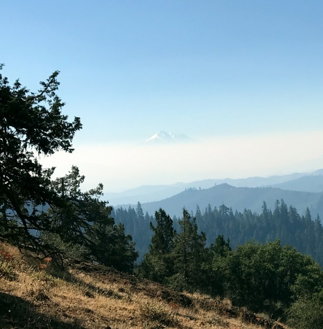
California Section R, which runs from Ashland, OR, to Seiad Valley, CA, has a steep start, and right now is covered with smoke. That smoke is all over Ashland, Medford, and the Rogue River Valley. It’s hard to breathe, and is playing utter havoc with my asthma. There’s more, and worse, smoke and wildfire in the northernmost sections of California.
Mt. Shasta, almost obscured by the northern California smoke
Going uphill is taking me longer, and longer, and longer. I understand why. I get it. But it’s sapping the fun out of my hike. And it’s draining my energy, mentally, physically, and emotionally. I don’t think I’ve got enough energy to continue, and still enjoy myself. You’ll never find a hike which is all fun, all of the time. But if it’s not fun at all, for whatever reason, it’s time to rethink things.
So I did eleven miles today, plus another 1.5 mile roadwalk, to get to Callahan’s. And I decided to call my hike for the year.
Callahan’s has been a great place to make the transition. I got to wash my clothes, and wash me. And while the laundry was going, I talked with Steve.
He listened to me for a few minutes, and then I asked if it was too late to join the family camping trip to Madras, OR. Madras is on the centerline of the August 21 eclipse. The family was planning on a trip from the 19th through the 21st. All I had to do was to make it to Seattle on the 18th.
So within a half an hour, I had tickets on a midafternoon flight from Medford to Seattle, plus a shuttle ride to the airport. My head was spinning, but it was the right thing to do.
I pitched my tent in the small grassy area at the front of the lodge, and went to have dinner in the restaurant. I had filet mignon, and the largest piece of chocolate cake I’d seen in a long time. Because it was time to treat myself. Well.
I’m sharing the lawn with Michael and Karen, his niece. They’re great, and it’s good to spend time with like minded people, before heading home.
My final campsite, at Callahan’s
I made the right choice, but I wish I didn’t have to.
Slower than a snail going backwards this morning. And then I went down to the outflow stream to get water. There was nowhere simple to do this. I found a drip with icky critters, and said nope. Finally, I went downstream, scooted out onto a log, and managed to get a slow flow of gicky water. Three liters later, I was off.
Today was a much larger climb than I’ve had before. Again with the “I should be able to do this,” and then reality sets in. Even my playlists weren’t doing the trick, as I plodded up the hills, along dirt roads, through gates onto and off of private property. Like yesterday, I have no recollection of anything interesting. It just…was.
I reached my destination about six. The spring water was delicious, especially after the gick of the morning. The spring itself was under a lid, with water flowing out of all sides. It was really easy to rinse and fill my water bottles.
There were several tentsites, which filled over the next couple of hours. Mine was next to the spring access trail, so instead of directing traffic all night, I used a few branches to make an arrow in the dirt.
I slept in a bit this morning, given my short miles. There were camp chores that needed to be done…emptying trash, rinsing socks, etc. It was nice to have access to running water, a trash can, and an outhouse!
While I was busy with my gear, one of the guys from the family came over with a cup of (hot! real!) coffee. He asked about my food, and I told him a bit about hiker hunger, magic, food choices, and so on. A little later, he showed up with bacon and eggs, plus a Gatorade. Score! I was grateful, to say the least.
The rest of the day, unfortunately, was kind of a blur. Ups and downs. Fatigue, both physical and mental. More stops than I cared to admit. I have no idea what the trail was like; all I wanted to do was just knock off miles.
And then, a treat. Imagine for a moment that you’re on the trail, hot, tired, and discouraged. Suddenly, you find a group of hikers laughing and talking, taking a sit-down break, and just enjoying life. You head over, introduce yourself, and find this.
Ice cold, potable water! With a special touch! I drank my fill, topped off my containers, and hung out for awhile. Just what the doctor ordered 😊
I plowed on a couple more miles, and came to the Hyatt Reservoir, my goal for the day. I found a campsite by scrambling up a small hill, to an unused road at water level. The outlet made its own waterfall, and listening to it was a good way to fall asleep.
Everyone was gone when I got up this morning. Well, except for a doe, who was busy at the picnic table, twisting and turning her head to get every last crumb that might be there.
As always, today’s plan revolved around hills and water. The first six miles were 1200 feet uphill, fairly steep. Nothing compared to last year, but I did my best to ignore that. I chugged along, and at the crest I crossed out of the Rogue River National Forest. I grabbed a quick snack, and headed downhill.
My next water stop was two miles ahead. There was a large sign on the trail, and I traipsed maybe a hundred yards to the piped spring. This means that an actual plastic pipe had been inserted, to make it easier for hikers to fill their bottles.
I loaded up with enough water to take me five more miles downhill, to the road leading to the campground.
Klum Landing County Park has a large campground, although today it was practically deserted. The campground hosts were gone for some reason, and the only party in sight was an extended family, with a campfire, making dinner. Heh heh heh…it’s Yogi time.
I took my sorry, hungry looking self up to their campsites, said that I was a backpacker, and asked if they knew where the campground hosts were located. They said no, the hosts weren’t here, but could they get me anything? Maybe dinner?
Booyah! Barbecued ribs! To Yogi means to get food, drink, or other good stuff merely by being a grubby long distance hiker. It’s not exactly begging, more like playing the situation to your advantage. Really, it’s not begging.
I thanked them profusely after dinner and a bit of campfire time, saying that the ribs were a great improvement over “freeze dried something or other.” They were wonderful folks.
Tomorrow is a short day, only nine miles, to stage for water on the following day. I relaxed a bit, and hit the rack when it got dark.
Got up this morning, and headed for the bushes, just uphill from the campsite. I took a trekking pole, because it was just steep enough to want one. When I had just finished, I felt a sharp pain. I flung my pole in surprise, and realized that yes, while in the bushes, I had been stung by a bee, in the…ankle. Sorry, not too interesting 😉 . I immediately headed back to camp, and administered some AfterBite and hydrocortisone.
Fast forward half an hour, and I was ready to go. Except that I was missing a pole. Uh oh. So I went up the hill, and aided by a Swiss couple, I eventually found it. Near a nest of ground bees, one of which nailed the Swiss guy. I almost walked into the nest, but he got my attention, and I very carefully backed away.
I was dragging for the first hour or so, even through the nearly flat stroll up to the trail. Par for the course, I guess. It’s still really frustrating, and is almost guaranteed to trigger self doubt. What do I think I’m even doing here? It’s pretty hard to beat back. But I put on my music, and that helped.
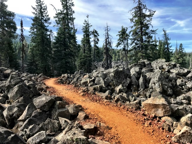
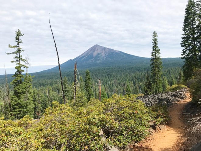
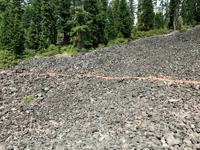
Today’s stretch was a reminder of some of last year’s hike. Pumice! Lava! But it was much easier tread, and it wasn’t nearly as hot and exposed as the stuff in central Oregon. I actually spent some time taking pictures.
Pumice trailMt. McLoughlinAcross a lava fieldLayers of smoke in the distance
I needed to load up on water, again five liters. I knew that I’d reach a cache at the end of the day; while you *never* rely on caches, multiple hikers saying there were multiple gallons is a pretty good indicator. There was supposed to be a spring near that, a few hundred yards off of the trail, but even with some decent bushwhacking I wasn’t able to find it. Oh well, I tried.
Just before the shelter, I found the cache and loaded up. I didn’t want to retrace my steps in the morning, so I filled up with everything I’d need through midday the next day.
At the shelter trail junction, I found an awesome sign!
Perspective
South Brown Mountain Shelter has a few bunks, and a trail register. And, it appeared, a zillion mice and a few rats. So I signed the register, and beat a retreat.
There were a lot of tentsites, and an infamous pump. Apparently the pump handle has been broken all year, and the USFS hasn’t had time to come fix it. This is a pretty critical junction for water, at least for slower hikers, and the lack of handle has been mighty frustrating. Thank God for angels and their gift of a water cache!
So remember Old School? We met at the Diamond Lake trailhead four days ago. Turns out he made it through Section C, on the East Rim Drive, just as he planned. As a SOBO thru, he’s mighty fast, so he did 75 miles while I was having a zero and meandering down the trail. We talked about his hike, and found that both of us had been to Philmont. That’s always a great conversation topic!
We were joined by Josh (Just Josh, no trail name), and a kilt-wearing guy named Naked Ninja. I didn’t pursue that one, other than to say “nice kilt”. One other guy showed up just as I was crawling into the tent. It was a full house, so I skipped recording my blog entry…it gets a little awkward talking to myself. I’ll take care of that tomorrow.
I dragged myself out of the (very comfy) motel bed, far too soon. But I had to finish sorting and loading, plus I had a breakfast to eat! Around ten, I turned in my key, and sat down to a lingering French toast breakfast. I like this “spoiling myself” deal!
Diamond Lake, at the resort. Mt. Bailey is in the background.
Ginger and her husband Bill showed up at noon, with their behemoth truck (yes, I have truck envy). They took a day off from their family reunion, just to schlep me around the fires. They totally rock! We spent a couple of hours driving east and south around Crater Lake. The smoke was pretty obvious, and I was glad to not be breathing it!
It was really weird, skipping over an entire section. In this case, it’s 75 trail miles. I was mighty disappointed to miss Crater Lake, although from the pictures there wasn’t much to see (nor much to breathe). Hopefully next year.
Once we got to Fish Lake, I claimed my resupply box, plus ice cream all around. Yum! And then we opened up the box, plus my Diamond Lake resupply, on the tailgate of the truck.
At Ginger’s request, I walked through my resupply process. Basically, food is divided into four types: breakfast, dinner, midday, and beverages. I plan for n anticipated days, based on terrain, mileage, and current hiking speed. Then I add ½ day, just in case. I then put n breakfasts into the breakfast bag, n dinners into the dinner bag, and n+1 sets of midday snacks into their own bag. For midday, I’ll have a protein bar, a meal bar (I like ProBar), banana chips, Snickers and/or peanut M&Ms, and maybe something else. For my beverages, I have a Starbucks Via, plus a variety of electrolyte drinks.
Because I wasn’t doing Section C, I had a full resupply box that needed a new home. Ginger was heading out to do a six day section, the following week, so this was perfect. She cherrypicked, and then we took the leftovers to the hiker box inside. A hiker box is a place for hikers to leave extras. It could be extra food, like I was doing, or maps for somebody heading in the opposite direction, or a bottle of bug repellent, etc. I put my stuff in there, including a few items from PackIt Gourmet (a backpacking food company with really tasty, non-chemically food). The vultures descended, and I had a satisfied grin.
Ginger and Bill had to head back to the reunion, so we hugged goodbye. What a blessing, to have good, selfless friends.
Ginger and I
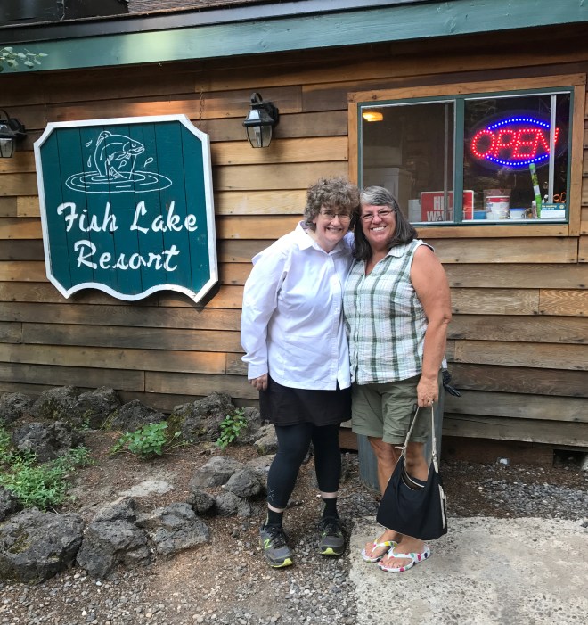
Fish Lake is a much smaller, more hiker friendly resort than Diamond Lake. They have a small restaurant, with a limited but excellent menu. There are lots of tables and other places for hikers to hang out, sort boxes, etc. And there’s a PCT hiker area, maybe a tenth of a mile around the lake. I had a big cheeseburger for dinner, and talked with Steve for awhile. Then I got my pack situated, loaded up with five liters of water, for tonight and tomorrow, and headed to the campsite.
The only other hiker in the site was a guy named Randy, of about my age, from my neck of the woods. He had been hiking with his wife, but she had to get off the trail with severe foot pain. He was continuing on. We talked for awhile, while setting up camp, and I hit the rack early. Tomorrow, Section B.
Last night was slightly interesting. I had just nodded off, aided and abetted by my trusty melatonin, when I heard thunder. I tried stuffing my fingers in my ears…la la fuzzy bunnies…but I had to admit defeat. It was time to put the rain fly on. Ever tried to do that when you’ve got melatonin in your bloodstream? For me, it’s problematic. Nevertheless, I managed to stand upright, figure out which way was which on the fly, attach the fly, and hammer in a few stakes. And I didn’t even fall over! Victory was mine!
I needed to get to Diamond Lake by early-mid afternoon. So I hustled through my camp chores, got water, filtered the water, and got more, and then I trotted off towards my destination.
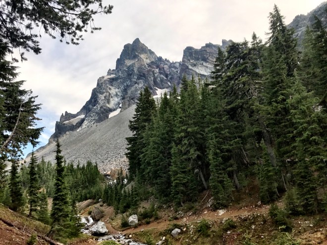
Mt. Thielson from Thielson Creek
Once I got to the day’s high point, the Thielsen Creek Trail junction at 7300 feet, I called the resort to see a) if they could pick me up at the highway at 1:30, and b) if they had a room. So I was scheduled for a pickup, at “whenever the maintenance man has time in the early afternoon,” and put on a waiting list for a room. I crossed every finger and toe. Which made for difficult hiking, but such is life.
Mt. Bailey overlooking Diamond Lake. Notice the smoke.
It was six miles of unabated downhill, it was fast, and it was fun. There’s something good about increasing your speed, when you’ve been struggling. So switch on the music, insert the headphones, because I have a date with real food.
I knew I was getting closer, because the highway is also the northern boundary of Crater Lake National Park. Hence, the sign. Plus, it had other cool information.
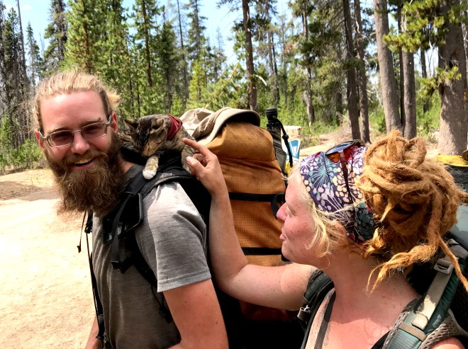
Around 1:00, I reached the trailhead. It’s about half a mile off of the highway, so I couldn’t linger. There were three hikers there, one of whom was Old School (who I met later in my trip), and I had a delightful surprise. I’d seen pictures of Taylor, aka Yachti, online, and what caught my eye was her traveling companion…a four month old kitten! Manzanita, also known as Trail Bait, was adopted by Yachti in California. She was trained to ride on top of a pack, and would happily sit there all day long. By night, she had become a world class mouser, so much so that she hardly ate any kibble. Yachti and Trail Bait were hiking with a friend, whose name I didn’t catch, but who clearly liked giving the kitty a ride.
The most adorable thru of 2017
I had to catch the van, so I headed south. Old School was headed that way too. His plan was to do Section C, but on the East Rim Road, rather than either the (West) Rim Trail or the PCT. As it was still very smoky, I was comfortable, if frustrated, with my plan.
Fifteen minutes after I reached the highway, the Diamond Lake van pulled up onto the shoulder. The driver, accompanied by two grandsons who bounced all over the back of the van, loaded up my pack and I was on my way. It was about a fifteen minute ride downhill to the lake, and I thanked him profusely.
I went into the lodge, introduced myself, and asked if there was a room. YES! It wouldn’t be ready for a couple of hours, but I was happy to wait. In the meantime, I had a gigantic sandwich, and prepared to do my laundry.
Remember that bright white shirt?
Laundry, for a long distance hiker, is a bit unusual. Naturally you need to wash everything that is washable. Yes, all of your socks, all of your underwear, and so on. The one drawback to this plan is the dearth of other clothes. So you can either go full commando, or you can wear your raingear. My shell is fine, but my rain skirt is just a wrap. How to keep from getting too…umm…drafty? I have diaper pins (they don’t rust) on the back of my pack, and I use them for drying clothes on the trail. So I use those baby blue diaper pins to keep my rain skirt together. Hiker trash style.
Once I got the laundry back to the room, it was shower time. Nobody leaves a ring in the tub like hiker trash. Then I exploded my pack. This is exactly what it sounds like, except perhaps for the dynamite. Gear was everywhere, to be sorted, cleaned, and repacked. I got through a good chunk of it, and then headed down to the restaurant…
where I had PRIME RIB.
Stuffed beyond hope, I staggered back to my room, went face-first on the bed, and slept for twelve hours.