With clear blue skies and warm sun in the forecast, I grabbed my pack, and Booker the Rhodesian Ridgeback (aka the Wonder Pup), and we headed north. Today’s destination was the Chain Lakes Trail between Mt. Baker and Mt. Shuksan, very near the Canadian border.
To get to the trail, you take the Mt. Baker Highway (542) up past the ski area. At the very end, you’ll find Artist Point. This is a fantastic place to take out-of-town guests. Even those who aren’t inclined to hike can have an in-your-face view of Shuksan, just by stepping out of the car. And there are a variety of short trails for those who would like to explore just a little.
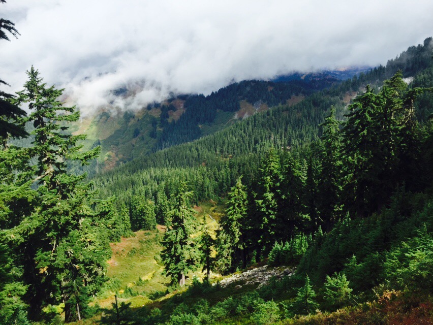
Booker and I had a little longer trail in mind. The Chain Lakes Loop explores several lakes in the area, and winds over ridges, through basins, and back up again. It’s a moderate level hike, eight miles and about 1700 feet net elevation gain. The trail has its fair share of talus (rocky slopes), but no scrambles or anything even close. We took the counter clockwise route, out of the Artist Point parking lot. More trail info can be found at Washington Trails Association’s Chain Lakes page.
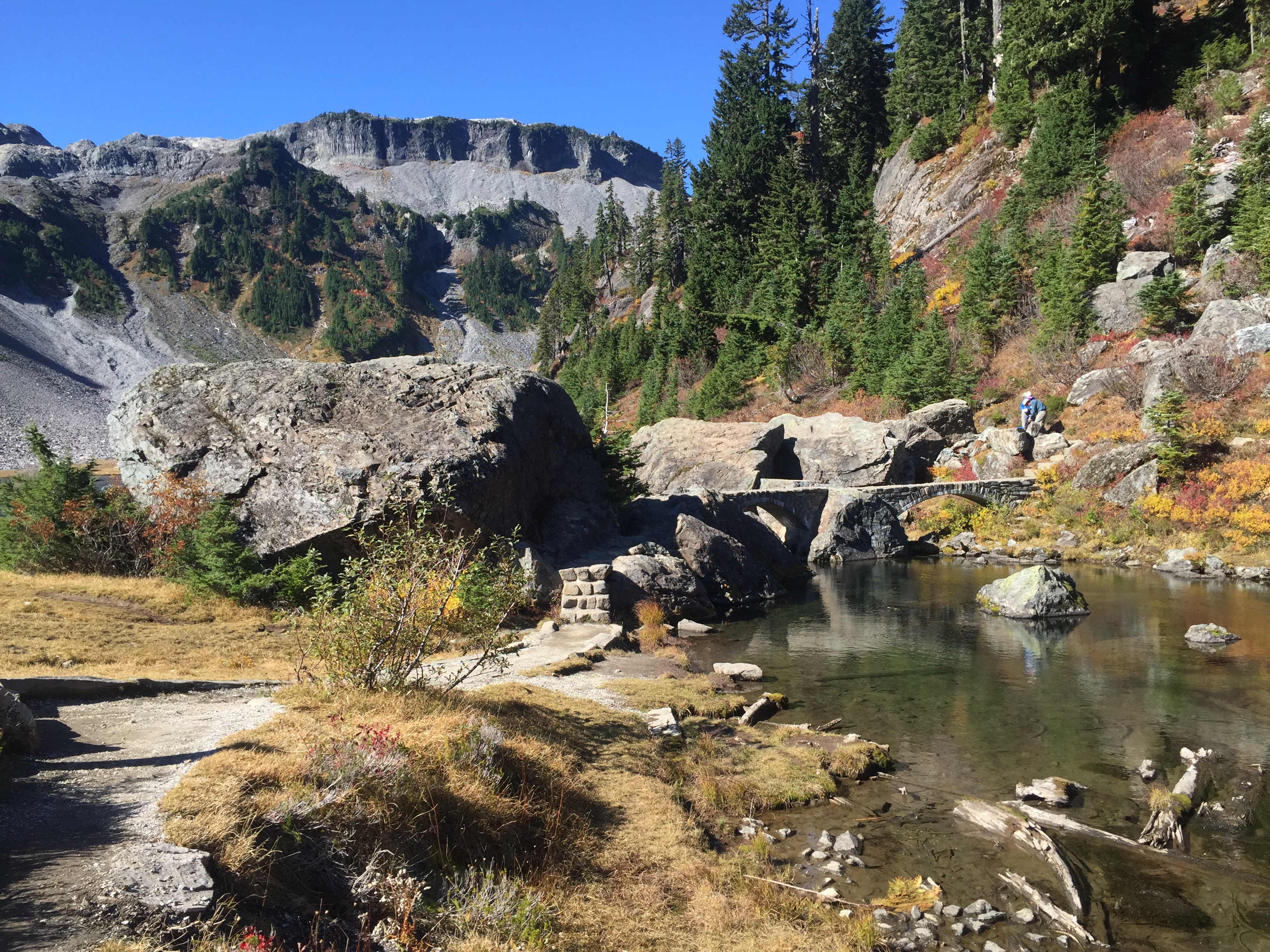
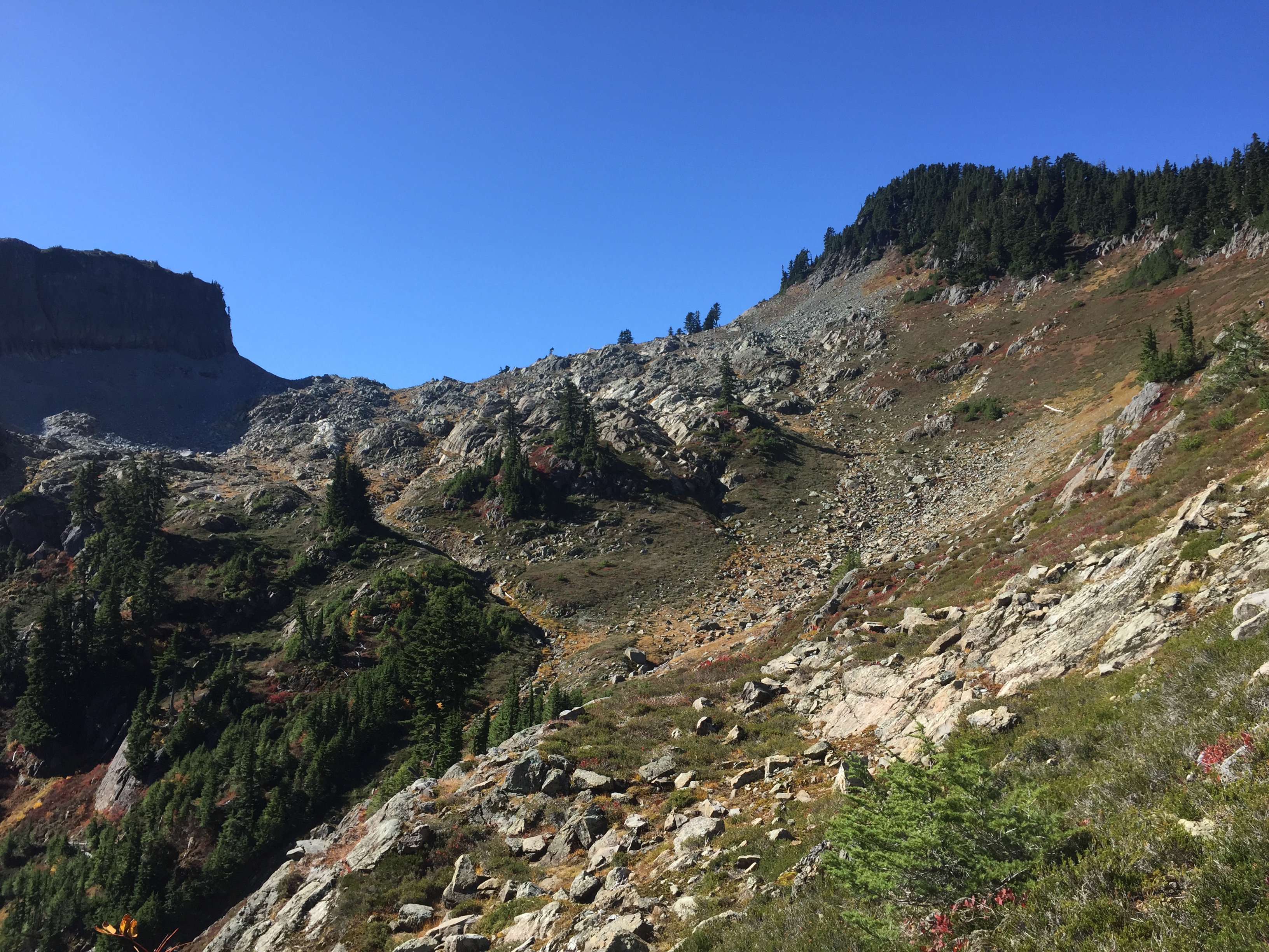
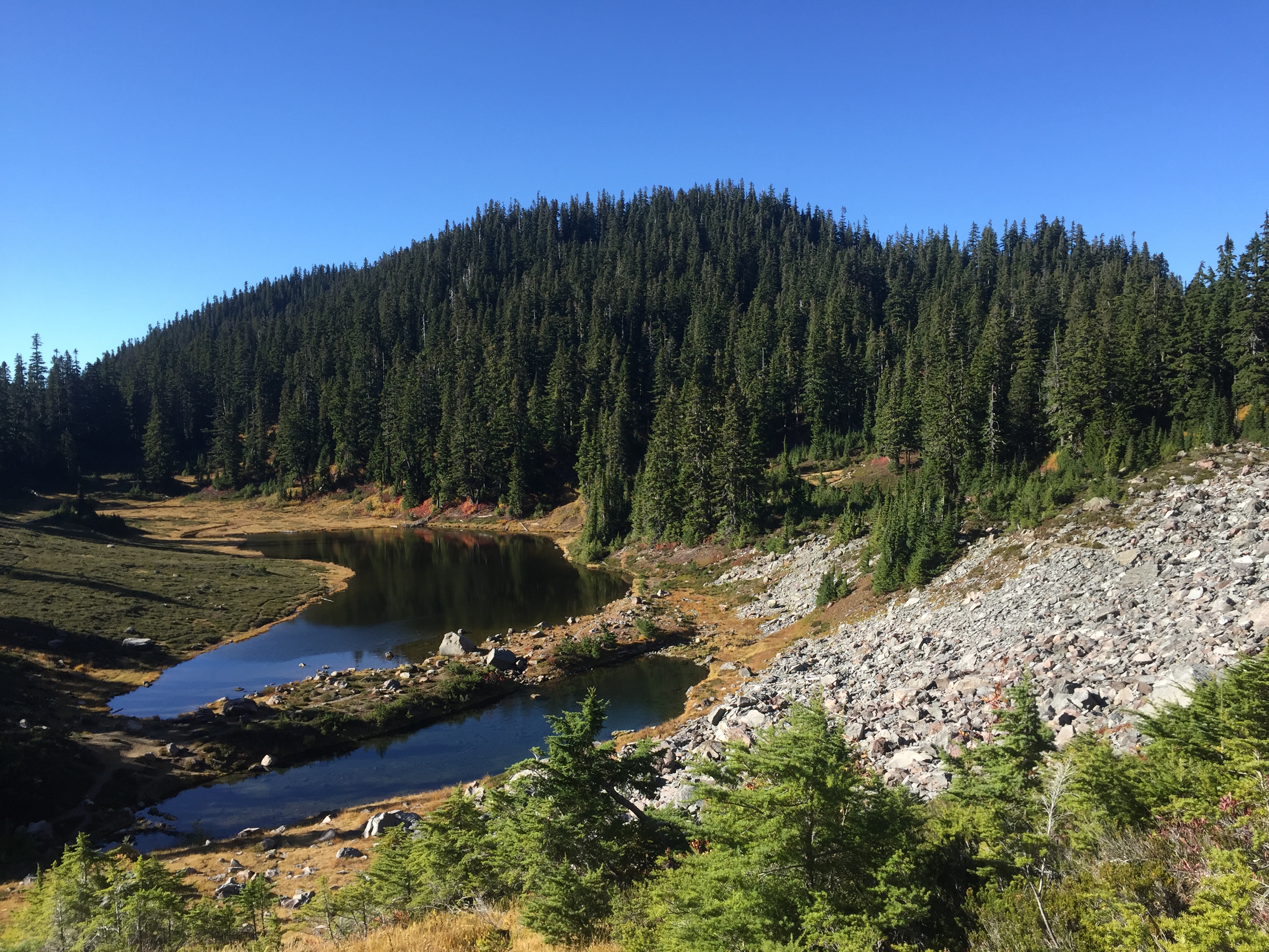
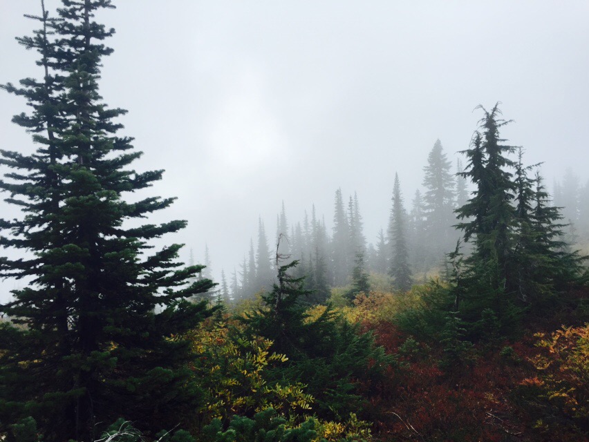
Descending into the Bagley Lakes basinStone bridge across the stream between the Bagley Lakes. Table Mountain is in the background.Looping around the stream and the northern Bagley Lake.Climbing out of the Bagley Lakes basin, to Herman Saddle. Table Mountain is to the left, and Mt. Herman is to the right.Mt. Shuksan, as seen from the climb out of the Bagley Lakes basin.The view from the saddle. Shuksan is to the left, Table in the middle, and Baker to the right. A heck of a place to have lunch.Booker enjoyed his milk bones, and then relaxed on his new blanket. Rough life.Descending toward Hayes LakeMazama LakesAfter traversing the Hayes/Iceberg/Mazama Lakes basin, the trail climbs through several talus slopes on the other side of Table Mountain.Booker was glad to reach the saddleAnd the second saddle proved just as gorgeous as the first. Table Mountain is on the left, Shuksan on the right, and if you look carefully you can see Artist Point in the center.
When I grow up, I want to be like Bronka Sundstrom and her hiking partner. They are 90 and 92, respectively, and are still avid hikers. Did I mention she’s a Holocaust survivor as well? Check out this article from Craig Romano, a local guidebook author.
And check out his website, CraigRomano.com, for more articles and photographs of Our Fair State (aka Washington).
I’m in print! Big hat tip to Jessi Loerch of the Everett Herald. She spent the better part of a day talking with Jerry and Andrea Dinsmore, and several hikers who were at Dinsmores’ Hiker Haven for the day, as part of her series on the Pacific Crest Trail. Bravo!
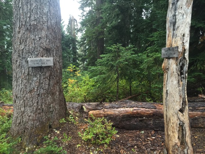
For those of you new to my blog, welcome! I’m all about hiking the PCT and other area trails, and introducing women and girls to the wild places.
If you’re interested in following my PCT journal for this year, this is the first day . Enjoy!
Liz, Anna, Julieanne, and Jennifer, on top of the Tooth of Time at Philmont Scout Ranch
When my son was in early elementary school, he asked us if he could join Cub Scouts. It was a no-brainer for us, and in that moment we became a Scouting family.
Fast forward several years, through Cubs, and into Boy Scouts. By this time, I had helped organize several campouts, day hikes, and backpacking trips; frankly, I was getting a bit jealous. I started leading trips myself. But the question in the back of my mind was, “what about the girls?” Long story short, in 2010 we formed a Venturing Crew, and my friend Jennifer and I signed up as advisors.
Venturing is an arm of the BSA. It’s designed for older teens, and is coed. Our crew was always predominately girls, and our focus was on hiking, backpacking, and going to Philmont Scout Ranch in northern New Mexico for two eleven-day backpacking trips in the Sangre de Cristos.
Prior to our time at Philmont, none of the girls had much experience on the trail. We worked with the entire crew on basic backpacking skills: cooking, first aid, navigation, you name it. When we got to Philmont for our 2011 trek, our Ranger was impressed with how much our crew already knew.
Even with all the skills in place, several of the crew members didn’t have a lot of miles under their boots. But they persevered, through heat, challenging weather and rough terrain.
We were given the opportunity to return to Philmont two years later. By now, our girls were experienced backpackers, and one of them, Julieanne, was chosen to be the crew leader for the trip. The crew leader is in charge of everything, from navigation to conflict resolution. The adult advisors are there to backstop the crew leader, but only as a last resort.
Julieanne and Anna were veterans of our 2011 trek, and their experience was invaluable in 2013. For the advisors, it was great to be able to rely on them.
I love seeing women adopt the backcountry as their own. For Julieanne and Anna, they earned the moniker Mighty Hiker Women of Philmont. I’d happily go hiking with them any day.
I celebrated my 51st birthday on the trail this year. What a tremendous gift, to be in the mountains, surrounded by God’s creation, and sharing it with like-minded people.
Some of my favorite people to meet were those of a certain age. I got to know many people over fifty…some were closer to 80, and doing long distance hikes. They weren’t the fastest on the trail (remember Hike Your Own Hike?), but that wasn’t important. The trail belongs to them, just like me, just like those fresh out of school.
So in celebration of the vintage hikers on the trail, I’m sharing an incredible poem from Nanao Sakaki. Hat tip to Sage Clegg for the reference (She’s a Triple Crowner and outdoor educator, at http://www.sageclegg.com …don’t miss her website).
Break the Mirror
In the morning
After taking cold shower
—what a mistake—
I look at the mirror.
There, a funny guy,
Grey hair, white beard, wrinkled skin,
—what a pity—
Poor, dirty, old man,
He is not me, absolutely not.
Land and life
Fishing in the ocean
Sleeping in the desert with stars
Building a shelter in the mountains
Farming the ancient way
Singing with coyotes
Singing against nuclear war–
I’ll never be tired of life.
Now I’m seventeen years old,
Very charming young man.
I sit quietly in lotus position,
Meditating, meditating for nothing.
Suddenly a voice comes to me:
“To stay young,
To save the world,
Break the mirror.”
Long distance hiking is never a race. Hopefully, everyone is out on the trail to seek their own experiences. Some enjoy photography. Some are recharged by sharing the journey with other hikers. Some prefer to go it alone as much as possible. It’s called “Hike Your Own Hike,” and that diversity is one of the things that make trail life so awesome.
A handful of years ago, one woman discovered that her hike involves crushing long distances, with speeds that leave the rest of us in the dust. Her trail name is Anish, and in 2013, she set the Self-Supported Fastest Known Time for the PCT, at 60 days 17 hours 12 minutes. That’s for 2650 miles. If you’re doing the math at home, that’s an average of nearly 44 miles per day.
“Self-Supported” means just that. Nobody’s carrying your gear for you, so that all you need on your back is water and a few snacks. It’s all up to you…setting up camp, making your food, you name it. And “Fastest Known Time” is also just that. There’s no record book for the long trails. You don’t get a gold medal. Sure, people are impressed, and maybe you get an interview or two. But you do it for you. Hike your own hike.
Anish tackled the John Muir Trail (JMT) last year, hoping for a FKT. She didn’t meet her goal. And like many of us who deal with low self-esteem, it haunted her.
This year, on August 1st, Anish set out to test herself again. She headed for Mt. Katahdin, Maine, to attempt the Self Supported FKT for the Appalachian Trail, which runs from Katahdin to Springer Mountain, Georgia, a distance of 2185 miles.
This her post from today, on the “Anish Hikes” Facebook page.
The trail has a way of answering the questions you most need answered, even if you are afraid to ask.
Those that have followed me for a while know that I have struggled with self-esteem my entire life. You would think setting the PCT speed record would change that.
Yet it only gave the negative thoughts an even more insidious way to demoralize me, especially after I failed to set the JMT record last year.
“The PCT was a fluke. You were only the benefactor of lucky circumstances. You aren’t athletic. You aren’t able. You’re a charlatan.”
On and on the whispers go.
I had to come here, to the AT, where my quest to find myself began 12 years ago and face those voices once and for all, alone.
I was to afraid to ask, but the trail knew the question in my heart:
“Was the PCT a fluke?”
The AT answered with a resounding, “NO!”
I wrestled not against the trail or external forces, but with them. If it were easy the whispers of inadequacy would continue. Instead I was challenged every single minute.
In the dark hours when I was tired, lonely, and hungry, that is when the demons came, “Why didn’t you stop with the PCT record? It will be your greatest achievement in life. You won’t ever do anything else. Now you’re out here and you’re in over your head. You will fail. You can’t do this. And everyone is going to know that you are nothing.”
But, every footstep I took was a choice. A choice to face my own perceived inadequacies.
Every footstep was a commitment. A commitment to deny that there was any truth to the words of the internal foes.
As the miles dwindled into the double digits I became aware that I was crushing more than miles. I was crushing a lifetime of self defeating beliefs.
So now, I walk off of Springer Mountain, alone just as I came. My pack, my feet, and my heart are light, unburdened at last.
And, I am aware that the end of every journey is simply the beginning of the next and that, far from being behind me, the greatest achievements of my life lie ahead.
New Appalachian Trail self-supported speed record: 54:7:48
Congratulations, Anish. I am so very happy for you.
To follow Anish, check out her Facebook page: https://www.facebook.com/AnishHikes, and her blog: http://runhikelivelove.blogspot.com/
As a female hiker, it gives me great joy to meet other women on the trail. I love talking with them all. I learn a lot from the experienced hikers, and I gain a fresh perspective from those who are brand new to the trail. But I refer to all of them as Mighty Hiker Women.
Many of our friends and family don’t understand why we go into the backcountry. They tend to be concerned for our safety. That’s fine, up to a point. But when the fear of the unknown keeps us from hitting the trail (or, frankly, going on any new adventure), we need to rethink that fear. When we’re not sure exactly how to hike, or what gear is helpful, we need to learn what works. And one of the best ways to understand what the trail is really like is to talk with the women who are out there on a regular basis.
I’ve met, and in some cases mentored, women of all ages, who were headed to the backcountry for the first time. I’ll be sharing some of these stories.
I’d also like to share the stories of women who have been at it for awhile. I’m not necessarily talking about elite athletes (although I’ll talk about them too); the focus will be Everywoman, hiking her own hike, and learning and growing along the way.
And I’ll post hiking resources, especially woman-centric.
The trail belongs to all of us. And that’s a beautiful thing.
Note: If you are a women or girl who loves to hike, or know someone with an interesting hiking story, let me know. My aim isn’t necessarily to re-tell stories, but rather to point people in the direction of new friends.
It’s the end of my hike. I’m pretty sad that I didn’t make the border this year. I know I made all the right decisions, but it’s still tough. Two acts of Mother Nature got in the way, and sometimes that’s just the way it happens. The day after I got home, I learned that the storm I experienced was the strongest summer storm on record in our region.
My family and friends have been wonderfully supportive, and they are completely on board for next summer as well.
So, by the numbers: I did 252 miles on-trail this year, from Divide Camp near Mt. Adams (2239) to Lake Sally Ann near the Glacier Peak Wilderness (2491), plus eight more miles of entry/exit.
Last year, I hiked from the Bridge of the Gods (2144) to Divide Camp, 95 miles on-trail. And later that summer, I hiked from Cady Creek to Lake Sally Ann to Red Pass (2503).
Next year, God willing, I will rejoin the trail at the North Fork of the Sauk River Trail, just south of Red Pass, at mile 2500. And then I will hike to the Northern Terminus, at Monument 78, and PCT mile 2650.
But it’s far more than just the miles. I’ve met some incredible people along the way. I’ve pushed myself through pain and fatigue. I’ve seen some stunning parts of God’s creation. And I’m so very grateful for all of it.
So, here’s to the adventures of 2015, and may 2016 bring me to Canada.
In July 2016, I headed out for several sections. Check out my next adventureshere
Late last night, I had to come up with an exit plan. There are several access trails along this stretch of the PCT, going east and west, but ultimately I chose to go back four miles to the eastbound Cady Creek trail; it was familiar from last year, the PCT segment was familiar from yesterday, and it dropped the fastest into less exposed territory. I would end up at a trailhead in the neighborhood of Lake Wenatchee. The only problem with the trail was that it is overgrown. Not as in “push the brush aside,” nor “I need my machete.” This was overgrown as in “Dr. Livingstone, I presume?” And sodden brush of that caliber gets your raingear soaking wet in a hurry. But it was still the best option. What I didn’t realize was that, given the fire danger, the Wenatchee Ranger District had closed every single one of its trails, including the eastbound ones from the PCT. I texted Steve to meet me at the Cady Creek (Little Wenatchee Ford) trailhead, probably mid-afternoon.
In the meantime, I spent the night reheating my bottles. This was yet another reason to bail: I was using a lot more than my budgeted fuel; I always have extra, but at this rate there was a chance my canister could be empty before I hiked down the Suiattle.
Steve didn’t get the bailout message until very early Sunday morning. And I didn’t get his latest until the same time. Apparently they were now predicting wet snow.
Within an hour of getting my message, he was on the road, with (per my request), lots of dry clothes, towels, etc.
I got up early that morning, stuffed all of my Snickers into my rain shell pocket, and began the process of keeping the must-stay-dry stuff into heavy duty plastic, while separating it from the can-get-wet stuff, and then shoving the tent in the outside of the pack. This totally threw off the balance, especially because the tent was much heavier than normal.
As soon as I was done, I turned on my music, and headed south. It was crucial to keep going; even stopping for a couple of minutes made it hard to warm back up. I kept munching the Snickers, and heading down the trail. My plan was that, if Steve hadn’t arrived yet, I would hang out in the trailhead privy, wearing my sleep clothes and my quilt, until he got there.
I did stop for a minute at the Cady Creek junction, to say goodbye to the trail; even though I was doing the right thing, I was still mighty sad.
Cady Creek Trail Junction
9.5 miles, lots of heavy brush, a few scrambles, a heavy creek to ford, some rather interesting blowdowns, and 5 hours later, I arrived at the trailhead, and my waiting husband. The first thing I said to Steve was “252 miles…this year.”
He gave me an enormous hug, and after I had changed into my dry clothes, we headed down the road. There were barricades in place, due to the closure, but we just drove around them. The next stop was burgers and shakes at the 59er Diner, and then we headed over Stevens Pass towards home.
I woke up to a bit of very infrequent rain, and so I put my fly and quilt out to dry. But all of a sudden the wind picked up dramatically, and the rain started dumping, from a squall line coming through. The wind was strong enough that there were whitecaps on tiny, sheltered Pear Lake. I pulled all my gear back inside, grabbed my Ursack, and had breakfast in my tent. When the squall passed, I quickly threw my gear together.
The guys began to stir as I was breaking camp. One of them was in a hammock under a tarp, but two of them had pitched an inexpensive tent on a deceptively flat space with no duff or other debris on it…in other words, a puddle in the making. They were afloat this morning. I gave them the updated weather forecast; my guess is they packed it up and headed downhill.
The destination today was Lake Sally Ann. The cool thing about this was that I’d pass the Cady Creek Trail, which was where I joined the PCT late last September, for a brief section to White and Red Passes. Connecting more dots…gotta love that.
Just a little ways after I started this morning, I had my first really decent view of Glacier Peak. And that is something I’ve been waiting for, all year long.
First view of Glacier Peak
Unlike Friday, the rain was much more enthusiastic today. But every once in a while I’d get a glimpse of the sun.
A tiny bit of sun on the fall foliage
The last bit of sun I saw
The terrain here isn’t the up-and-down-the-ridge variety of Section J (although I know that’s coming). The less rigorous workout made it easier to maintain my body temperature under my rain shell.
Five miles and 1200 ft in, I got to the junction with the West Cady Ridge trail, which leads to the North Fork of the Skykomish road. I had hiked this trail in July of 2014, although I was stopped short by traverses across snowfields. But it was kind of like connecting a dot.
From there, it was two miles to the Cady Creek Trail junction. This was where I had joined the PCT for the White/Red Passes section last August.
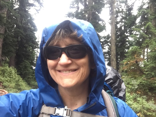
Selfie in the rain, before traversing the ridges to Lake Sally Ann.
And then it was four more miles of open, uphill ridge traverses until I reached Lake Sally Ann, at Mile 2491. This is normally a gorgeous hike, full of beautiful foliage and a large population of grouse. But on this day it got wetter, and wetter, and windier, and windier, and colder, and colder. Is anybody detecting a trend here? By the time I reached Lake Sally Ann late in the afternoon, it was VERY wet and VERY windy and VERY cold.
I set up my tent in record time, in a fairly tight grove of trees, and away from the lake to keep wind exposure to a minimum. Setting up camp in heavy rain is predictably more complex than in other weather situations. For example, the gear in ziplocs need to be sheltered while I pull my mattress out of its waterproof bag; I then inflate the mattress, which keeps me off of the damp floor, and then get all of my gear into the tent, making sure that everything is inside plastic. This doesn’t protect things from the damp air, but it saves putting my gear in the inevitable small puddles.
I filled every one of my water containers and got in the tent. While this was happening, the wind was increasing even more, and because I wasn’t moving while gathering water, and because I was keeping my main insulation layer in the tent, to stay dry for that night, I got very cold, very fast. Later that night, I estimated the wind was steady at 20 knots, gusts to 30, and that was inside my grove of trees. And the rain was torrential and quite literally sideways; it didn’t let up at all. The lows were probably in the mid 40s. I can only imagine what the lake looked like; I am sure there must have been whitecaps.
Once in the tent, in my quilt, with a large space blanket under my mattress (to reflect heat back upward), and in all of my dry sleep clothes, I made a massive dinner and poured the calories down the throat. Cheesy pasta, hot lemonade, two kinds of candy, you get the idea. From there, I made hot water bottles from each of my two smaller water containers. I couldn’t boil, as they would have melted, but they were mighty warm.
I was able to text Steve again, and asked for a very specific weather forecast: the region around Glacier Peak, about 5000 ft elevation, for a week, beginning tomorrow. That forecast? Winds staying steady, rain staying steady, and low temperatures dropping into the mid 30s. The hypothermia risk in that kind of weather is about as severe as you can get.