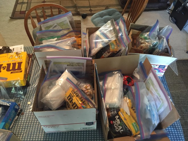
Dehydrated food. Ziplocs. Recipes. Mail orders. Counting. Averaging. Checking. Checking again. Wondering if my Snickers and M&Ms stash would survive a house of teenage boys (hint…they did). Toiletries, sundries, and meds, oh my. And this was just the resupplies.
You wouldn’t think food would take this much effort, but it’s a balancing act. How many days? How many miles? What’s the elevation gain/loss? Are there any hazards which might slow you down? How much nutrition do you need, and is it (kinda sorta) balanced? Do you have enough calories per ounce (100+ is optimal)? Do you have enough variation so that you won’t go bonkers?
And gear. New pack. New hydration setup. An umbrella (yes, an umbrella). Spraying Permethrin on every piece of clothing, in preparation for the notorious Oregon mosquitoes.
I can’t believe it, but it’s getting close. On Wednesday, Steve is dropping me at the train station, and I’ll head to Eugene. My longtime friend Robin is hosting me for the night, and in the morning she’ll drive me up to Willamette Pass. And then…it’s time for a hike.
As many of you know, I’ve had my nose to the proverbial grindstone since January. I’m enrolled in a professional certification program at Cascadia College, north of Seattle. I’ve been working on the finer points of mobile app design, web app design, UI, and a lot of programming. I’ve been doing pretty well, and am looking forward to jumping back into the software field in a year and change.
But! Spring quarter has just ended! And I have a total of four weeks in which to prepare, almost from scratch, my 2016 Pacific Crest Trail section hike!
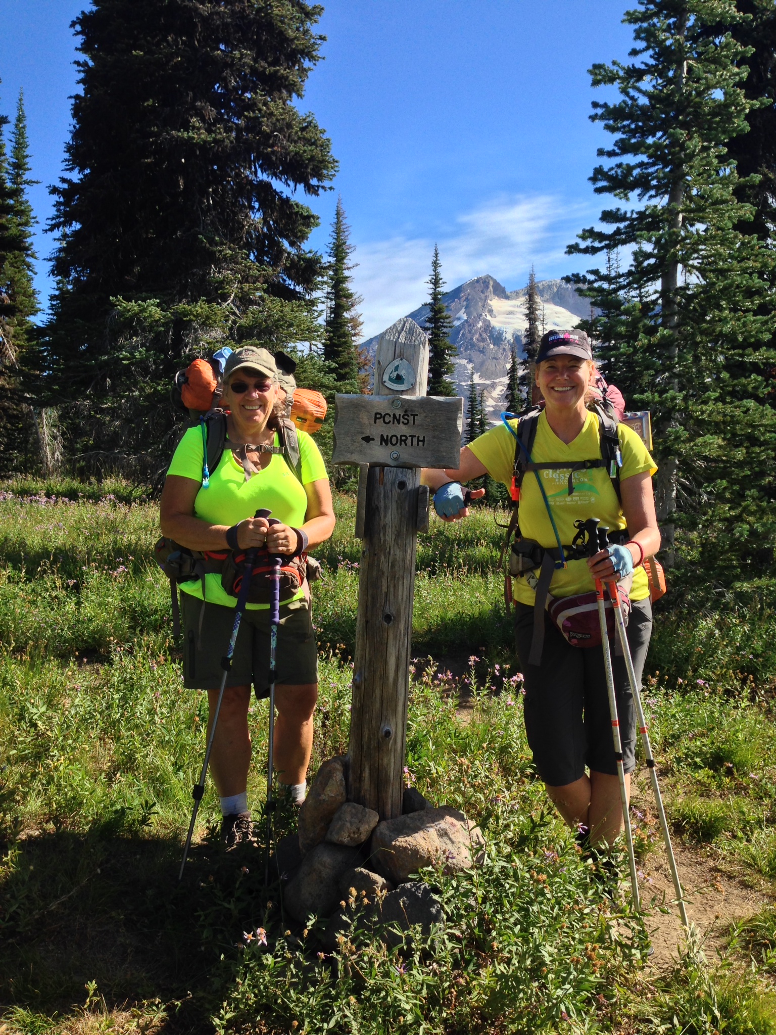
This year my hike will be in two parts. The third week of July will see Steve and I head to Willamette Pass, right about the halfway point on the Oregon PCT. I’ll hike north 240 miles, to Cascade Locks, where I started in 2014. I love connecting the dots!
Then I’ll head home for about ten days, while Steve is away on business. When he returns, I’m heading back to where I left off last summer, just south of Glacier Peak. And from there, it’s off to Manning Park, BC: 175 miles, to the northernmost point on the trail.
The tests are taken, the projects presented, and the books are neatly stacked to one side. Rest Step is in the house!!!
I was up to my eyeballs, studying for midterms, when wonder of wonders! I started talking about the upcoming hiking season. My better half (aka the World’s Most Longsuffering Husband) said he’d know when hiking season was approaching, by the round-the-clock sound of my dehydrator.
I made a face at him, but I realized he was right. This time last year, I was starting to get things organized, food wise.
I developed some favorites last year, banana chips and pasta+olive oil+parmesan chief among them. But I know I need to expand my repertoire, or at least my understanding of best trail food practices.
Enter Brenda Braaten, Ph.D, R.D., a long distance hiker with a desire to help others eat wisely on the trail. www.thru-hiker.com has referenced her work, and has a great series of articles on trail nutrition. See specifically Pack Light, Eat Right.
Once those pesky midterms are over, I plan to dive in and start making plans for summer. On the other hand, maybe I’d better wait until after finals…
Mountain Education, a non-profit Wilderness Safety organization, has just announced a new course at Stevens Pass, in March.
Snow Basics is a three day course focusing on snow hiking, camping, and safety. Right now they’re gauging interest, and if there are eight or more folks who would like to sign up, they’ll come up from Tahoe to teach the course. I’m strongly interested myself, as I’d like to round out my snow skills.
For more info, check out http://mountaineducation.org/snow-basics-course-description/. And if you’re interested, ping Ned Tibbets at ned@mountaineducation.org.
I’ve been neglecting my blog lately. I’ve had a couple of short hikes, but my time has been taken up with family things. I’ve also been spending the last month or so learning Xcode and Swift, with the hopes of building a iOS app.
But the biggest news for me is that I’m heading back to school! I spent ten years as a software engineer, before retiring to raise the kids. I’ve been trying to break back in to the field, but other than a two-year stint maintaining very old code, I’ve not had much success.
Enter the Washington State Worker Retraining Program, for which I’m finally eligible. In a nutshell, the state will be paying a large chunk of my tuition, to go to Cascadia College, a very tech-heavy community college close to home, where I’ll be studying for several software certifications. Oh, and I’ll get internships as well, which is the best way to interview for a job.
I’m pretty excited about the possibility, even though it will certainly take away from my day hike time. I’m going to try to get in a couple of hikes per month, and that will be a good thing.
Last day on the trail, and I definitely have mixed feelings. I topped off my water at the bucket spring. 2.5 L, which was 1 L too much in retrospect, although I didn’t know that so many seasonal streams would be flowing. Right when I finished Terri & Ginger showed up; I headed up the hill as they were topping off.
The burn resumed almost immediately after I left camp, and probably half of the day was in the burn. But that allowed for more views. Before long, I was able to see St. Helens, and then Adams. The views were opening up, and my mood got brighter and brighter.
Terri and Ginger caught up to me, and we hiked together for most of the afternoon. The nice thing about “hiking together” on the PCT is that nobody is making you stay in a group. You hike at your own speed, and catch up eventually. No guilt, no fuss, lots of time for photography. One thing I did was take time to talk with people (when they wanted). I learned a lot, and really felt part of the community.
We hit a point all of a sudden where we could see four volcanoes: Hood, St. Helens, Rainier, and of course Adams. It was incredible. Four at one time is pretty rare, unless you’re on a summit.
Adams on the left, and Hood on the right.Hiking out of the burn.
This was one of those days where you keep stopping to take pictures, and each picture gets better. The pictures through the burn made quite a contrast, and eventually there was no burn…just beautiful trees, wildflowers, and of course the ever present Adams.
Mt. Adams: The Pinnacle and the White Salmon Glacier.Near the junction with the Round the Mountain Trail, which encircles Mt. Adams.Mt. St. HelensNot much difficulty crossing creeks this time of year.PaintbrushRockfall near the Round the Mountain trail.Rest Step!
Terri & Ginger decided to camp at Riley Creek, 2237. We had lunch a few miles before, amidst the wildflowers. They were heading down the following day, so once we hit Riley we parted ways. It’s been great to have such cool hiking buddies!
Firestarter (Ginger) and the Warden (Terri)!
Shortly after I left Riley Creek, I began to see some of next year’s goals: Rainier and the Goat Rocks.
Rainier is getting more and more visible.Next year, the Goat Rocks Wilderness.Crystal clear view.
Finally, the last push. My emotions were running high. I got a few more pictures along the silty creeks, and Lewis River. Just before my exit point, I met a group from my neck of the woods; when they heard my trail name, the instant response was “Mountaineers!” We shared a lot in common, and it was a great sendoff for me.
The creeks are full of glacial silt.A small, silty waterfall.The northwest face of Adams, and the Adams Glacier.Glacial streams, Adams’ northwest side, and nearing the end of my hike.
Divide Camp Trail. I cried. And took pictures of my return destination, for 2015, God willing.
This is the turnoff, where I head down and join the gang at Takhlakh. Happy and sad, all jumbled together.
And this is my return point for 2015, mile 2239.
The trail down was just tedium…rocky and ordinary. It mellowed out to duff at the end, and then I hit the road. Left turn, and a couple of miles up the foot-pounding hardpan. Probably 5 miles altogether.
Finally, the campground. I found the entrance, and the Ferrenbergs’ site. Sue & James were astounded to see me so soon, and I got a hero’s welcome! And fresh food!
And then the fam arrived. This was the best. I am very blessed to have a family, and especially a husband, who are cool with my need to hike.
I received a very warm welcome from everyone at camp, who plied me with food, drink, and a comfy chair.
And so, it ends with a few days at Takhlakh Lake. Some reminiscing, sharing a picture or two, a plan hatched for trail magic next summer while I’m hiking north. There is no way to adequately capture the experience, except to say that it was the hardest and most incredible hike ever, for me, so far. I’ve done two other long distance hikes, which both hold “best ever” status for a couple of different reasons. But this was about me, and what I could do. And I did it, glory to God.
Here’s to 2014…and next year’s journey north.
In July 2015, I returned to Mt. Adams, and headed north. You can follow my continuing adventureshere.
Before taking off, I asked RG and Pilgrim what advice they’d give to a noob. RG said just don’t get discouraged. Pilgrim said don’t take advice from people who don’t get what you’re doing. And you’ll always be tweaking your gear and learning new ways of doing things, even when you’ve been at this quite a while. And that’s fine.
I purveyed more Trail Magic, giving all of my leftovers to RG and Pilgrim. I now have only two 3000-calorie per day packs, which will give me enough left over for an extra day, in case I get delayed. Closest yet to my sweet spot. I need to plan for 12-mile days, and take less food. I’m putting together a rough meal plan, which includes a lot more fat, less carbs, more electrolytes, and less pre-fab meals. My pack feels a lot better. Finally.
Trailhead information kiosk and registration, as the trail enters the Mt. Adams Wilderness.
Yesterday was more or less flat, and that gave my bones a rest. Today began the last series of climbs. Terri (Warden) and Ginger (Firestarter) had two more days scheduled, so they split the difference. They had a ten mile day and ended up at White Salmon River (2226)
I stopped at Trout Lake Creek, 2221, to top off my water before the five miles to White Salmon River. I’m still having difficulty with the water need vs water availability balance. I think this will improve with a more steady pace (based on rough incline).
Stopped at Terri & Ginger’s camp to look over maps.Terri, Ginger, and I, at White Salmon River. I had so much fun hiking with these two!
I stopped with Terri and Ginger, and chatted and discussed routes, and then I headed another three miles uphill. After a mile plus, I climbed into the Cascade Creek Burn.
Just before entering the burn, you get this sign. The winds that night were fierce, and it was easy to see how trees could collapse. Fortunately, I camped outside of the burn.
Eerie, and desolate. And suddenly there was a lot more light. Many of the trees were barely standing, resting mostly on a shell of empty bark. I wouldn’t want to be here in a windstorm.
Entering the 2012 burn area, which covers a large portion of the west side of Adams.More of the burn.
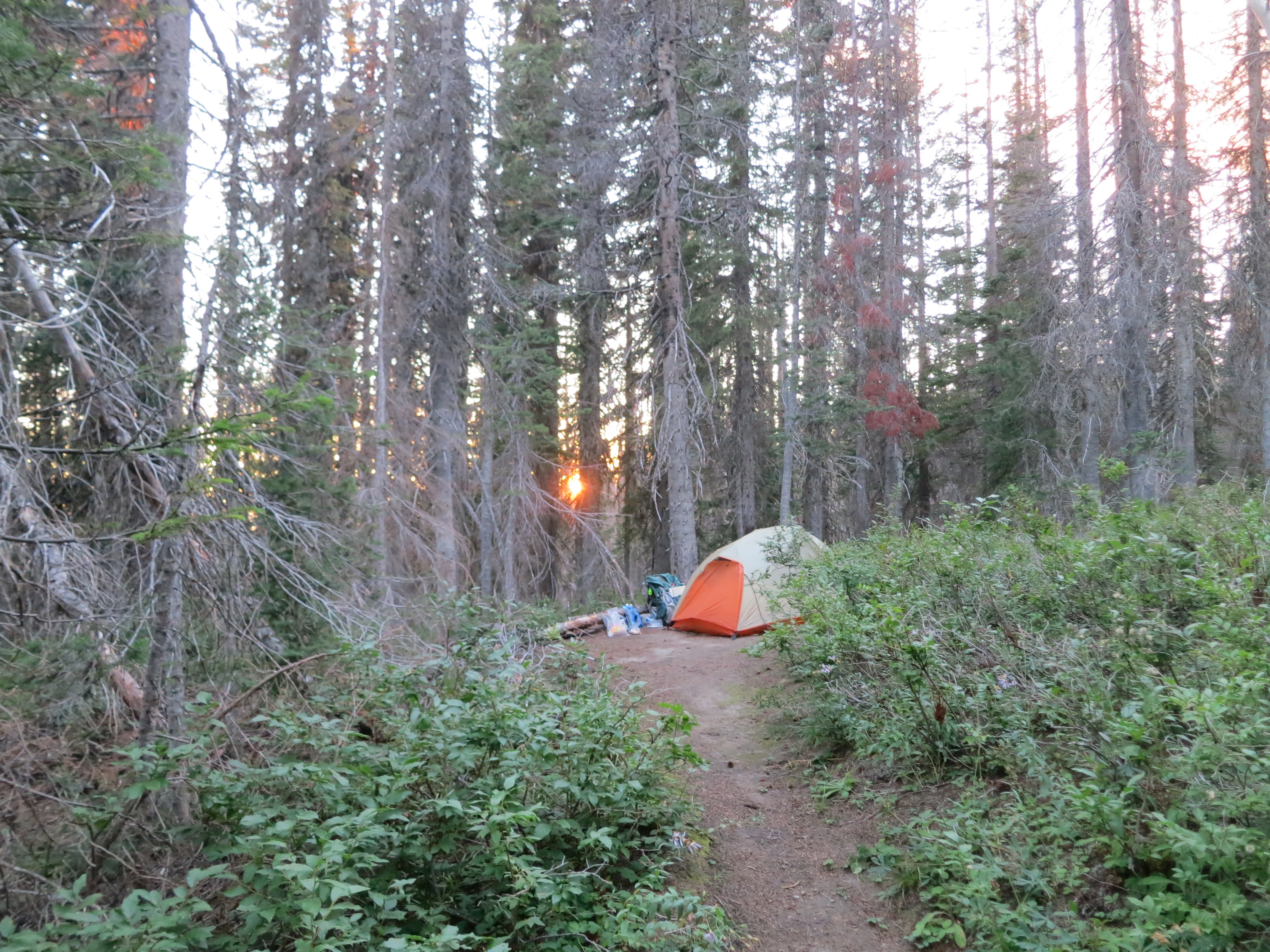
My tentsite is just past the burn, and next to a spring which requires the use of a bucket. Cool!
Water sign pointing the way to the bucket spring.And then you see this.And you carefully lower the bucket down into the small spring outlet. This was my favorite unconventional way to get water.
Miraculously I have signal, so I got to talk with the guys! One more day in the mountains, and I plan to make the most of it.
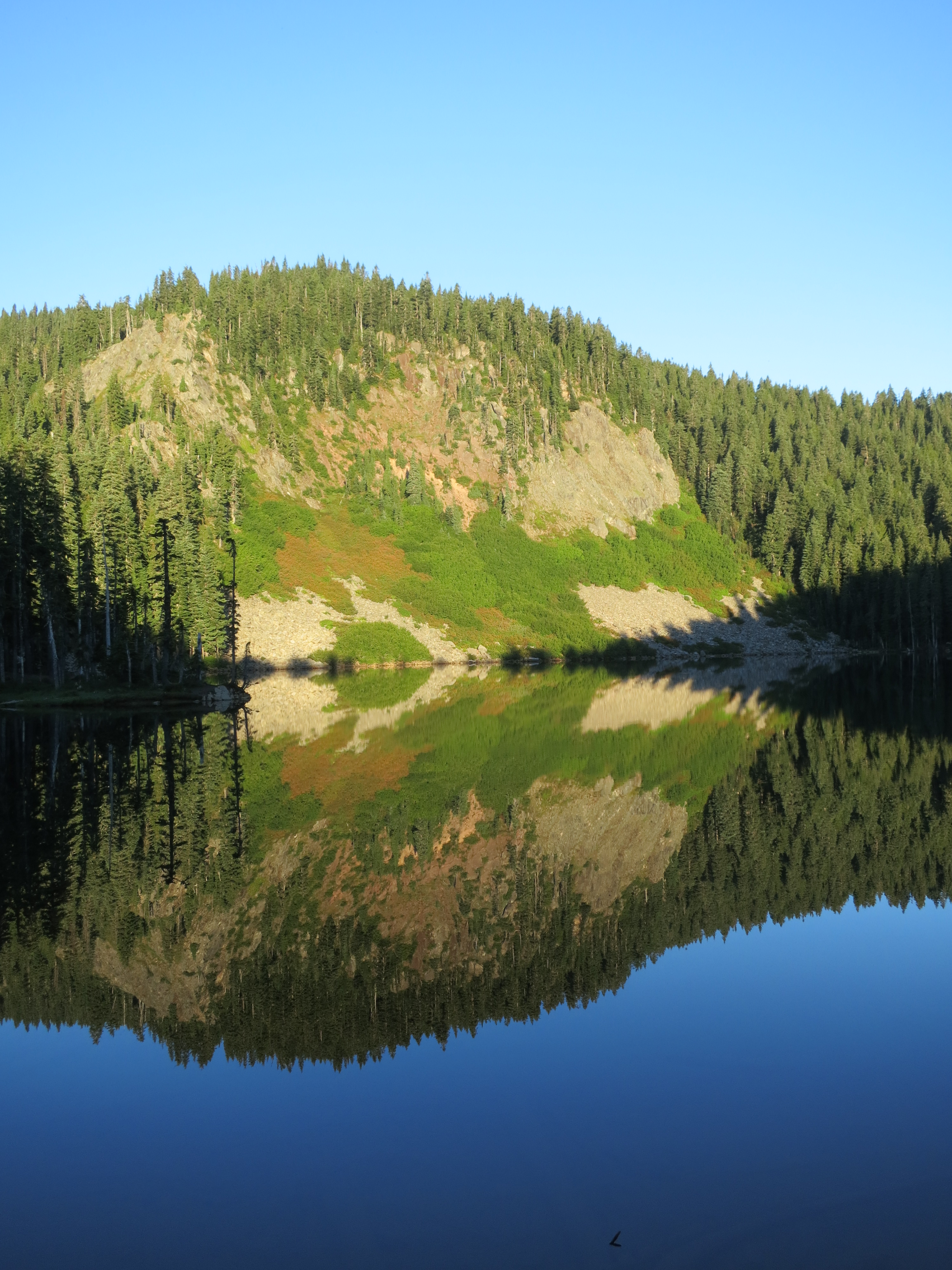
Blue Lake was gorgeous this am. Perfectly flat, with blue sky, and picture-perfect reflection. It was just the morale boost I needed, as I had been pretty down. And a thru-hiker named Leonidas stopped by my camp on his way north. Most excellent trail name.
I woke to this.
This style of sign is also used in Indian Heaven, and was just above my campsite.
After washing out my socks and hanging them on my pack, I hit the trail. It was a relatively flat day, finished by a gentle downhill, and that really helped my mood. I need to ditch more weight to find that sweet spot, but it’s in sight.
I did 13 miles to Mosquito Creek, which is miraculously lacking said insect. Along the way:
– Stopped at Deer Lake to backflush my filter, after the gick in Blue Lake. 2 days of silty lake water took its toll, but it’s fine now.
– Met Ronny, a local who loves to fish these lakes. He remains amazed at how few mosquitoes there are in the Indian Heaven Wilderness. It’s notorious for the overwhelming clouds of vicious bloodsucking doom.
– Met a family of four, up for day hikes, and chatted while they had their lunch. I got two baby carrots. My heavens, they tasted good. Lighthouse had just been there and Yogi-ed some celery. To Yogi means to look pitiful while non-backpackers are pulling out their vast quantities of food. I think I’m getting the look down.
– Met two retired men out for a day of berry picking.
– And met Acorn the Elder, a thru of about my age. He’s sporting a decrepit blue Ensolite foam pad, which he found at South Lake Tahoe; just seeing that pad brought back quite a few memories, and sparked a great conversation.
More spectacular lake scenery, this time from Deer Lake, where I stopped to filter water.And again, Deer Lake. The lighting was incredible.The old school PCT emblem can occasionally be found.Suddenly, Adams.Hiking through the northern Indian Heaven area.Closer still, with weather on the top.
Once again I’m sharing a campsite with Warden and Firestarter. We’ve hit it off well, and because we’ve got a similar itinerary, we’re doing everything together except the actual hiking.
After dinner we were joined by Roller Girl and Pilgrim. They’re SOBOs and had lots of good info for us. I love this part of being on the trail. RG and Pilgrim were great. They both got out of the army recently. Pilgrim did the AT last year and the PCT this year. He’s doing a yoyo and that’s where he met RG. We had an awesome time, the five of us.
Slept late after the 15 mile day. Pack is too heavy and is causing aches and pains. And my pace sucks. Figuring out the sweet spot, but not yet.
This is the current emblem used by the Pacific Crest Trail Association. The emblems (blazes) are placed periodically along the trail, especially where there’s a trail junction. There are several variations on the theme.A white blaze is also used to mark the trail.Are they huckleberries, or M&Ms? You be the judge.
I met a thru named Tim while having a trail side snack, and his hiking buddy Kara (Badass) came along a bit later. We started chatting about trail names, and she said they are either given to you based on something that happened, or are based on a story. She asked me about my backstory, and I talked about how I learned to hike. As an example, I told her how Dad had taught me the rest step, and, as an aside, that this week was the one year anniversary of Dad’s repose. She said that Rest Step would be a great trail name, and bestowed it on me. Henceforth, I am Rest Step!
Climbing toward the Cedar Creek Trail Junction, 2188Trail magic! This is the long distance hiking community’s name for random acts of kindness. This could be food, water, or just about anything. Here, Trail Toad has left water bottles for PCT hikers passing by…especially helpful in a dry patch.See that ridge in the distance, with Table Mountain? I was there a couple of days ago.Just before cresting the ridge, 2189
In the early afternoon, I passed the Grassy Knoll trail junction at mile 2189, and almost immediately crested a ridge. As I summited, I was hit in the face with black clouds and thunder. My destination was 1.8 miles down hill and I needed to be there to get water; I only had ½ L left, and the next water after that was well over 2 miles away. I made all kinds of speed, but got hit with the worst storm I’ve had on the trail in the last several years. Torrential rain, and hail ranging from ¼ to ½ inch. And it didn’t stop. I tried sheltering from the lightning, but I hit the proverbial lightning vs hypothermia dilemma, and had to continue down the trail. It wasn’t too far to the tentsite (and the necessary water). I couldn’t set up my tent without soaking everything, so I stood next to a large tree (in a heavily forested area, so much less lightning risk) and marched in place for probably another 20 minutes, to stay warm. When the hail had subsided, and the rain had started to slack, maybe 45 min later, I threw the tent up and got my cold soaked self inside. My NeoAir kept me off of the soaking wet tent floor, and I bundled up completely, while pouring calories into my system.
A rather grainy, out of the tent shot, of the beginning of the storm (courtesy Firestarter).
After the storm subsided, I stuck my head out of the tent. Two women were across the trail and invited me over. The Warden (Terri) and Firestarter (Ginger) are from Oregon, and are section hiking as well. They were getting a fire going, and we stood around steaming our clothes dry. Fun evening with good people.
Here I am at the campsite of The Warden and Firestarter, steaming my clothes dry. They were also caught in the storm, and we hung out together for the evening.My friends on the trail, The Warden, and Firestarter! We were all caught in the same storm, and we’re drying our gear. The three of us hiked together off and on for the rest of the trip.
Today was all about the walk and the mind game. I decided last night that I would do the last 15 miles to Panther Creek Campground, given that I’d done 9+ and 12+ the last two days. The first 4 were back up over another ridge, with 3 L because there was no reliable water until Trout Creek at 2174, or 9 miles. So a decent 4 mi up, a steeper 3 mi down, and then 6 mi of flattish. I was pretty damned tired, and my legs, hip, and feet were talking to me. Still looking for the sweet spot.
Looking up Trout Creek, 2174, after another long dry spell. About halfway through a fifteen mile day.
This section of the trail meanders through a variety of land ownership. After Trout Creek, there is a road walk, a meander through a tall grass field, a skirt of private property on both sides, and so forth. My feet and hip were pretty much done, so I was glad that it was pretty flat. Finally, I reached Panther Creek Campground, at 2179.
The last six miles of trail before Panther Creek Campground. It was mostly flat, and there were a variety of landowners.Crossing a grassy field, 2175The bridge over Wind River, 2177Finally! My best mileage to date, at 15.
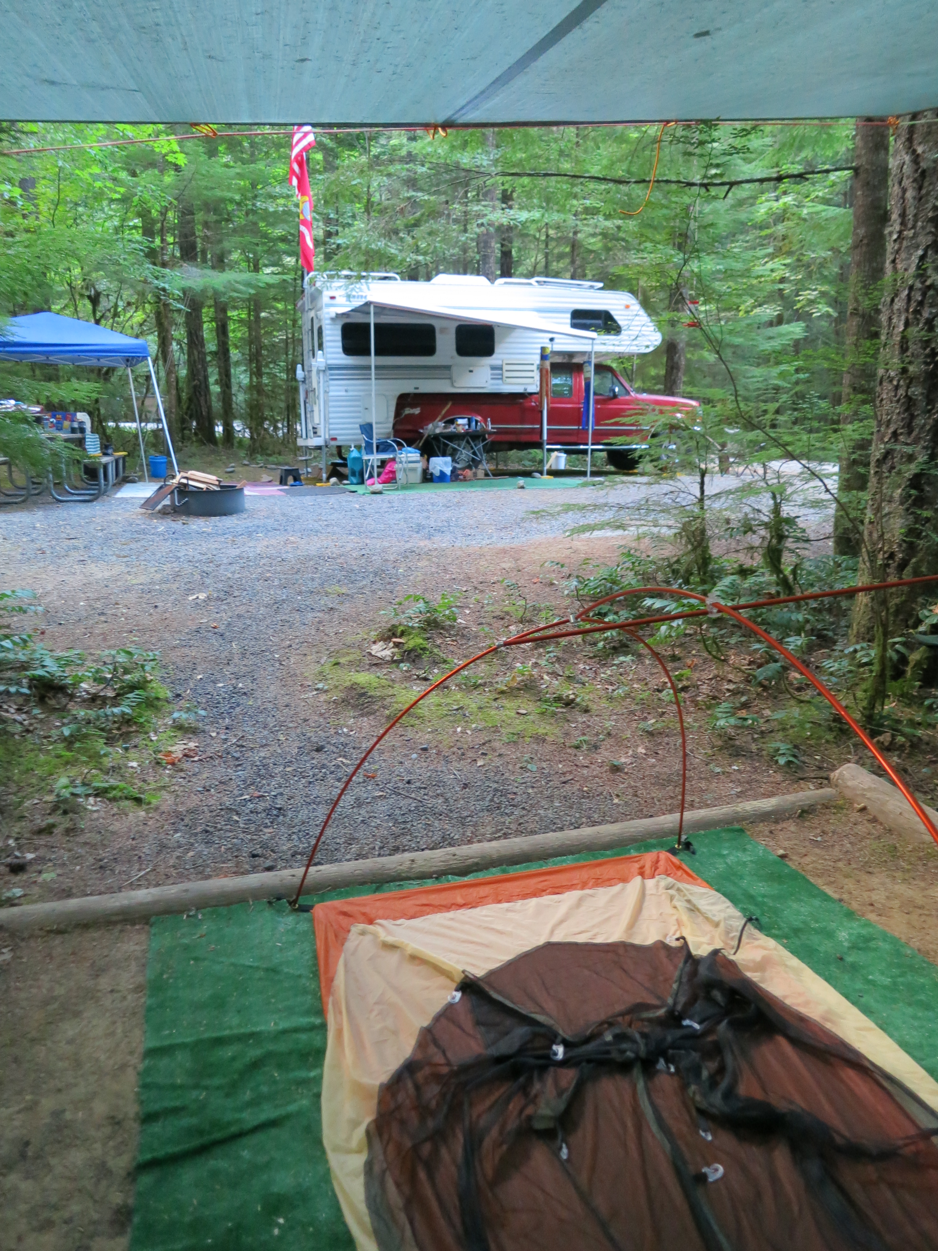
First stop was to see the campground host. Rumor had it that Panther Creek had tent spaces reserved for PCT hikers. This was not exactly the case. If it had been midweek, there would have been sites available, but this was Saturday. Larry, the host, said there were none, but he invited me to use the tent pad on his site. Woohoo! Flat astroturf, under a shelter. There are vault toilets, and water is available via hand pump. Almost the Ritz.
Larry shared his bounty with me: pre-pumped water for drinking and a quick bandanna bath, a table for making/ eating my dinner, and boiling dinner water from his trailer. And he gave me my first Trail Magic: an ice cream bar! Good merciful heavens, that tasted great. Easy night after a long day.
The campground host shared his tent pad, potable water, stove, and ice cream bars!